
How to Find a Photo’s Location With a Chrome Extension
· 11 min read
Short answer
To find where a photo on a web page was taken, install a Chrome extension such as GeoSpy – Photo Location Finder, right-click the image and choose “Find where this photo was taken”. The side panel shows the place, read from the photo’s GPS data when present or estimated by AI from visible clues. Analysis requires GeoSpy Premium.
A photo in a news story, a forum thread or a travel blog makes you wonder where it was taken. The usual route is slow: save the image, dig through its file details for GPS data, and upload it to an analysis tool when there is none. A Chrome extension can do the same job from a right-click, without leaving the page.
This guide walks through GeoSpy – Photo Location Finder, the extension we publish for geospys.com: how to set it up, what happens after the click, which photos give useful answers, where the method stops, and what leaves your browser. The same questions are worth asking of any extension built for this job.
Find photo location Chrome extension: what does it do?
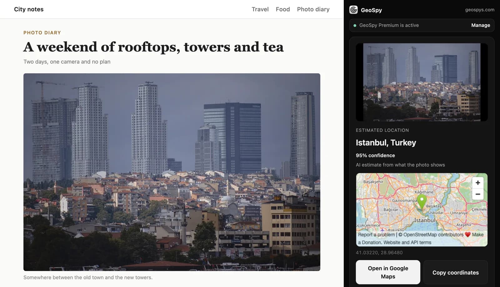
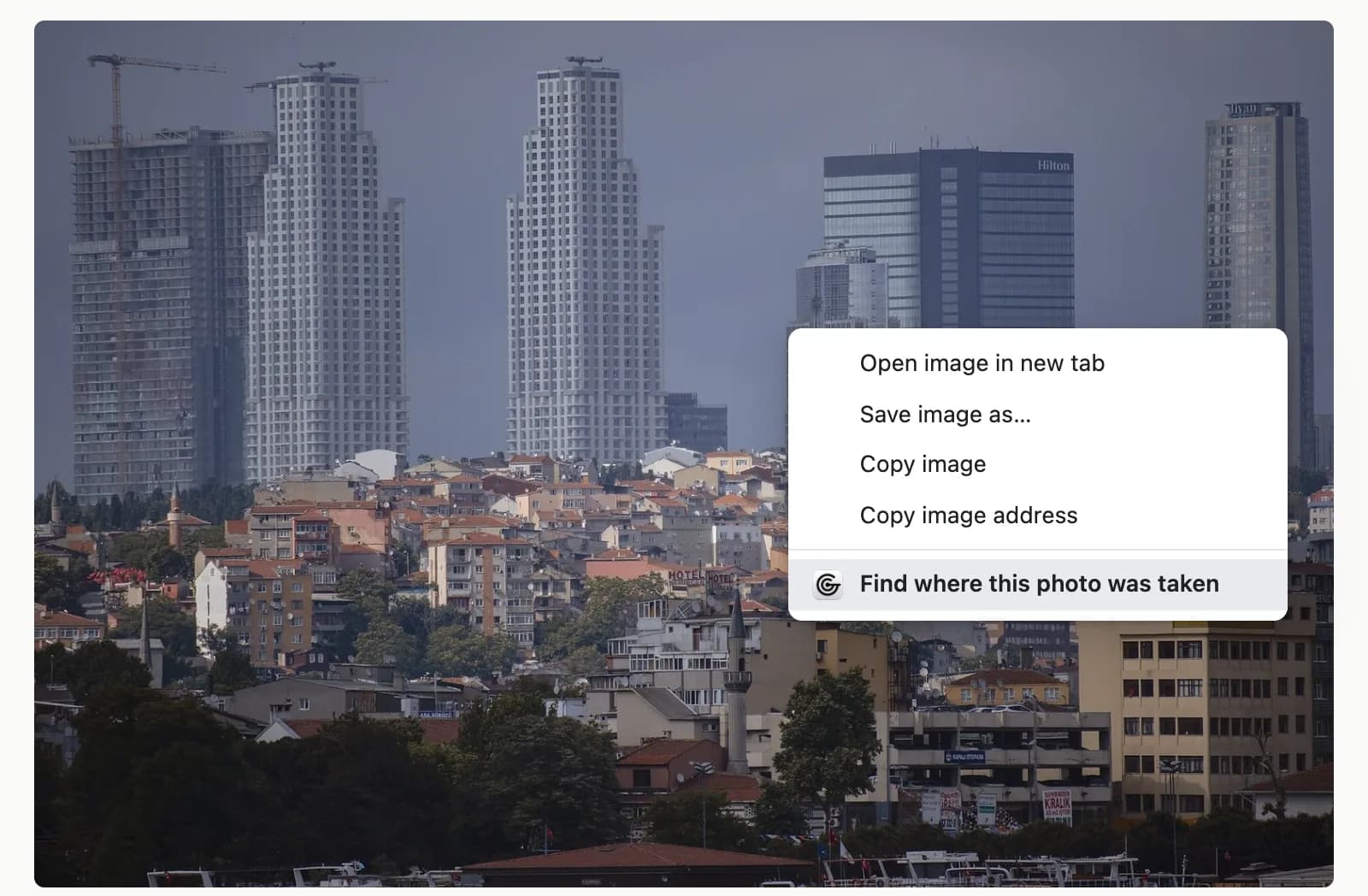
It adds “Find where this photo was taken” to Chrome’s right-click menu for images. Choose it and the photo is checked for GPS data first, then read for visual clues if there is none. The answer opens in Chrome’s side panel, next to the page you were reading.
Without an extension the check takes three steps. You save the file, look for GPS coordinates in its details, and upload it to an analysis tool when there are none. The extension starts from the photo where it sits, and the page stays open beside the answer.
Chrome has a built-in option that looks similar. Right-click an image, choose Search with Google Lens, and the results also display in the side panel. Lens is a reverse image search, though: it hunts for visual matches online. In Bellingcat’s 2025 tests, Lens beat most AI models on tourist areas and scenic landscapes, while the models did better in cities, where small details decide the answer. Google Lens and Yandex compared covers that side.
How do you set it up?
Add GeoSpy – Photo Location Finder from the Chrome Web Store, then sign in on geospys.com with your Google account, because the extension uses that sign-in. You need Chrome 116 or later. Installing is free; photo analysis requires a GeoSpy Premium subscription.
- Step 1Check your Chrome versionOpen Chrome’s More menu, then Help, then About Google Chrome. You need version 116 or later. Chrome gave extensions a side panel in version 114, and version 116 added the call that opens it in response to a click, which is exactly what the right-click needs.
- Step 2Add it from the Chrome Web StoreOpen the GeoSpy – Photo Location Finder listing and select Add to Chrome, then Add extension to approve its permissions. Extensions can’t be added in Incognito mode or as a guest.
- Step 3Sign in on geospys.comSign in on geospys.com with your Google account. The extension has no login of its own; it uses your geospys.com sign-in, and the analysis needs GeoSpy Premium: 7.99 US dollars a week or 29.99 US dollars a year, or ₺389 and ₺1,460 in Türkiye. What Premium includes is covered separately.
- Step 4Find the iconThe GeoSpy icon sits to the right of the address bar with your other extensions. Clicking it opens the side panel, ready for a photo from your computer.
How do you check where a photo was taken?
Right-click the photo and choose “Find where this photo was taken”. Chrome’s side panel opens beside the page and shows the place, a confidence percentage for AI estimates, and an OpenStreetMap map, with buttons to open the spot in Google Maps or copy the coordinates.
- Step 1Right-click the imagePick any photo on the page, such as a news picture, a forum post or a listing, and choose Find where this photo was taken from the menu.
- Step 2Read the resultThe panel names the estimated place. A confidence percentage appears when the answer is an AI estimate; a result read from the photo’s own GPS data doesn’t need one.
- Step 3Check it on the mapAn OpenStreetMap map marks the spot, and Open in Google Maps opens the same point in Google Maps for a closer look.
- Step 4Keep the coordinatesCopy coordinates puts them on your clipboard, ready for another map, a note or a report.
You can also start from the panel itself. Click the GeoSpy icon, then choose a photo, drag and drop one, or paste one. That is the route for pictures already on your computer.
What happens after you right-click?
First the extension looks for GPS coordinates inside the photo, which it reads from JPEG files. Then the photo goes to geospys.com. If coordinates were found, the answer comes from them; if not, AI estimates the location from what the photo shows and adds a confidence percentage.
Phones and cameras can write their position into a photo’s EXIF data at the moment it is taken. That reading is a measurement rather than a guess, which is why it comes first. On the web it is often gone by the time you see the picture, for reasons covered in why photos lose location when shared. It can also be edited, so treat coordinates as what the file claims, not proof.
Without GPS data, the analysis reads the picture itself: buildings, signs and the language on them, road markings, plants and landscape. How AI geolocation works explains how a model turns those clues into a place. Read the confidence percentage before the place name; a low number is a warning, not a detail.
What happens to different kinds of images
| Image | What the extension does |
|---|---|
| JPEG with GPS data | Reads the coordinates before anything else; the answer comes from them |
| JPEG or PNG without GPS data | AI estimate from visible clues, with a confidence percentage |
| WebP, AVIF, GIF or SVG | Converts it to JPEG, then analyses it |
| Larger than about 9.5 MB | Re-encodes it before upload |
| iPhone HEIC file | Not supported; convert it to JPEG first |
| Image the page won’t let it read | Cuts it out of a screen capture at display size |
| Photo with no usable clues | Says no location was found |
The screen-capture row deserves a closer look. A picture cut from a screen capture is a new image, so it carries none of the original file’s GPS data, for the same reason screenshots don’t keep a photo’s location. It is also only as sharp as it looked on screen. For full resolution, right-click the photo, choose Open image in new tab, and run GeoSpy from that tab.
Which photos give the best results?
Outdoor photos with specific clues: readable signs and shop names, road markings, distinctive buildings, plants and landscape. An original JPEG that still has GPS data gives the recorded spot. Interiors, close-ups, plain sky or water, and small or tightly cropped images leave little to read.
- Use the biggest version. Thumbnails hide the small text and details that narrow a location. Click through to the full-size image, or open it in its own tab, before you right-click.
- Prefer originals. A photographer’s own site or a forum that keeps original files is likelier to leave GPS data in place than a social feed; which apps strip EXIF data has the details.
- Look for words. Street names, shop signs and number plates do more work than scenery. Reading the clues yourself shows which ones narrow things fastest.
- Don’t force it. A blank wall, a plate of food or a sunset over open water gives any method little to work with. When the panel says no location was found, that is the honest answer.
Where does it fall short?
An AI estimate is a judgement from visible clues, and it can be wrong while sounding sure. GPS data can be missing or edited. iPhone HEIC files aren’t supported, images a site won’t let it read are taken at display size, and a photo with no usable clues gets no location at all.
Every visual method shares the first limit. When Bellingcat ran 500 geolocation tests on 20 AI models in 2025, using 25 photos that had never been published and carried no metadata, every model returned an answer that was entirely wrong at some point. The models also struggled with coordinates, which were often rough or simply incorrect. Bellingcat did not test GeoSpy, but the lesson applies to any estimate made from pixels: check the answer against the picture before you rely on it.
Checking is quick. Open the spot in Google Maps, compare the road layout, skyline or signs with the photo, and weigh the confidence percentage. When the clues are strong, placing a photo without GPS data by hand can confirm or overturn the estimate.
For iPhone photos, convert before you check. On a Mac, Apple’s instructions are to open the photo in Photos or Preview, choose File > Export, and pick JPEG. To have an iPhone save new photos as JPEG, go to Settings > Camera > Formats and choose Most Compatible.
The extension also needs a computer. Chrome’s help pages describe extensions as a way to customize Chrome on your desktop; on a phone, the Chrome Web Store only offers Add to Desktop, which installs the extension on your computer the next time you open Chrome there.
What does it send, and what can it access?
Nothing is read until you right-click an image. Then the chosen photo, its GPS coordinates if it has any, and a random install ID go to geospys.com, and the photo is not stored. The extension’s site access covers geospys.com only.
Each of its five permissions has one job. contextMenus adds the right-click entry, sidePanel shows the result beside the page, activeTab lets it reach the tab you clicked in, scripting lets it read that one image there, and storage keeps the install ID. Chrome’s permission reference lists no install warning for any of the five.
activeTab is what limits its reach. Chrome grants it only when you invoke the extension, for example from a context menu item, and only for the current tab; the access is revoked when you navigate away or close the tab. Apart from geospys.com, GeoSpy has no standing access to the sites you visit.
The same checks work for any extension. Before you select Add extension, read the permissions Chrome asks you to approve and the listing’s privacy section, where developers must disclose what user data the item collects; GeoSpy’s lists location and website content. If an extension asks to read and change data on all sites, ask why. Chrome’s Extensions menu can narrow that access to When you select the extension.
When should you not use it?
When the real question is where a person lives, works or is right now. Use it on your own photos, on published pictures such as news, travel or property images, and to test claims about where a photo was taken. The panel’s footer asks you not to track or find people without their consent.
Good reasons to ask are easy to find: checking a viral image before you share it, seeing whether a holiday rental’s photos match the town it claims, or naming the place in an old family picture. In each case the answer is a place, and it should stay one.
Frequently asked questions
- Does the GeoSpy extension cost anything?
- Installing it from the Chrome Web Store is free. Photo analysis runs on geospys.com and requires GeoSpy Premium, at 7.99 US dollars a week or 29.99 US dollars a year (₺389 or ₺1,460 in Türkiye).
- Can it find the exact address where a photo was taken?
- Only GPS data records an exact spot, and it marks where the camera was, not what it pointed at. Without GPS data, the result is an AI estimate from what the photo shows: a place to check on the map, not an address.
- Does GeoSpy keep the photos I check?
- No. When you choose a photo, the extension sends that photo, its GPS coordinates if it has any, and a random install ID to geospys.com, and the photo is not stored. Nothing on a page is read until you right-click an image.
- Can I check a photo saved on my computer?
- Yes. Click the GeoSpy icon to open the side panel, then choose a photo, drag and drop it, or paste it. iPhone HEIC files are not supported, so export them as JPEG first.
- Does it work on a phone?
- No. Chrome extensions run in Chrome on a computer. From a phone, the Chrome Web Store can only send an extension to your desktop with Add to Desktop.
- Why does it say no location was found?
- The photo didn’t show enough usable clues to place it. Try the full-size version, or another photo of the same place with signs, roads, buildings or landscape in view.
Sources
- Have LLMs Finally Mastered Geolocation? — BellingcatJune 2025: 500 tests of 20 models on 25 unpublished photos with no metadata; every model was at some point entirely wrong; coordinates often rough or incorrect; Google Lens led on tourist areas and scenic landscapes.
- chrome.sidePanel API — Chrome for DevelopersThe side panel API is available from Chrome 114; sidePanel.open(), which opens the panel on a user gesture, arrived in Chrome 116.
- The "activeTab" permission — Chrome for DevelopersTemporary access to the current tab when the user invokes the extension, including from a context menu item; revoked on navigation or tab close; no install warning.
- Permissions — Chrome for DevelopersNo install warning is listed for activeTab, contextMenus, scripting, sidePanel or storage.
- Fill out the privacy fields — Chrome for DevelopersDevelopers must disclose how an extension collects and uses user data, and the disclosures are displayed to Chrome users.
- Install and manage extensions — Chrome Web Store HelpAdd to Chrome and Add extension, no installs in Incognito or guest mode, Add to Desktop from a phone, and site access settings.
- Search with Google Lens in Chrome — Google Chrome HelpRight-click an image and select Search with Google Lens; results display in the side panel.
- Update Google Chrome — Google Chrome HelpCheck the installed version under More > Help > About Google Chrome.
- Using HEIF or HEVC media on Apple devices — Apple SupportSettings > Camera > Formats > Most Compatible for JPEG capture; File > Export from Photos or Preview on a Mac to convert HEIF to JPEG.
Keep reading
How to Find Out Where a Photo Was Taken
Four ways to work out where a photo was taken: GPS metadata, reverse image search, AI geolocation and reading the image itself. What each can and cannot do.
· 6 min read
How to Find GPS Coordinates in a Photo
Read the exact latitude and longitude stored inside a geotagged photo, understand the degrees-minutes-seconds format, and know how far to trust the numbers.
· 4 min read
How Does AI Geolocation Work?
An AI geolocation model does not look anything up. It reads the same visual evidence a trained human would, and its limits follow directly from that.
· 4 min read
Can Google Lens Find a Location From a Photo?
Sometimes. Lens names famous landmarks and finds pages that show the same scene, but ordinary streets stump it. When to check GPS data or use an AI estimate.
· 13 min read