
Can Google Lens Find a Location From a Photo?
· 13 min read
Short answer
Sometimes. Google Lens can name a famous landmark, read a sign or an address, and find web pages showing the same or a similar scene, and any of these can reveal where a photo was taken. It struggles with ordinary streets, and Google’s explanation of how Lens works never mentions reading a photo’s GPS data.
Google Lens is the first thing many people try on a mystery photo. It is built into Chrome, the Google app and Google Photos, and in May 2025 Google said more than 1.5 billion people were using it every month. So it is natural to drop in a holiday snap, a screenshot or a picture from a news post and ask where it was taken.
Lens can often help, but not in the way the question assumes. It does not look up a location for a photo. It recognizes what is in the frame and searches for matching pictures on the web, so a place only appears when something in the results names it. This guide sets out what Google itself says Lens does, where that works, where it fails, and what to use instead.
Can Google Lens find a location from any photo?
No. Lens finds a place only indirectly. It recognizes objects, reads text and looks for similar images and the pages that use them. When a landmark, a sign or one of those pages names the place, you have a location. When nothing similar is online, Lens has little to work with.
Google’s help page lists four kinds of results a Lens search can include: AI Overviews, search results for objects in the image, similar images, and websites that carry the image or a similar one. A location is not on the list. You get one when a result happens to name the place, such as a landmark Lens recognizes, a street sign it reads, or a travel blog that shows the same view with a caption.
Lens is one of several reverse image search engines (the main ones compared), and it runs at a huge scale: Google said in October 2024 that it handled nearly 20 billion visual searches a month. For finding a location, though, popularity is not the point. What matters is whether the place in your photo has been photographed and posted before.
What does Google Lens look at in a photo?
The pixels, and the web around matching pictures. Google says Lens compares the objects in your photo with other images, reads text, and may weigh words and metadata on the pages where matching images are hosted. If you allow it, Lens also uses your own location to improve results for places and landmarks.
Google’s longer explanation of how Lens works used to live at lens.google. That address now redirects to a product page, but an archived copy from September 2026 is still readable. It says Lens “compares objects in your picture to other images” and ranks them by similarity and relevance. It adds that Lens can also weigh the text, language and other metadata of the page where an image appears. That is the web page around a matching picture, not data stored inside your file.
- Landmark recognition. Google’s help says a photo of a landmark or building can bring up historical facts or opening hours. Its Lens product page lists landmarks, murals and artwork among the things Lens can tell you about.
- Visual matches. Lens shows similar images and the websites that carry the same or a similar picture. If one of those pages is a news story, a listing or a travel post, its caption may name the place.
- Text. Lens can copy text and translate it in over 100 languages, so a street sign, shopfront or menu becomes something you can search. On Android and iPhone, selecting an address in an image offers a Maps action.
Ranking also means Lens can sound surer than it is. Google’s own example is a dog that Lens judges 95% likely to be a German shepherd and 5% likely to be a corgi: it may show only the German shepherd. A place works the same way. The top result is the most similar picture, which is not proof that it shows the same spot.
Then there is location. When you agree to share yours, Google says Lens uses it to return more accurate results, for example when it identifies places and landmarks. In Google’s example, someone in Paris gets the Eiffel Tower rather than a look-alike elsewhere. That is the searcher’s location, though, not the photo’s. For a picture from last year’s trip, where you are sitting now says nothing about where it was taken.
Lens is also no longer a pure lookup. Its results can include an AI Overview, and in Chrome a follow-up question from the Lens side panel opens AI Mode. In Bellingcat’s August 2025 retest of 24 models, Google’s AI Mode was the most capable geolocation tool overall. Even so, Bellingcat found it sometimes named the wrong place with confidence.
Where does Google Lens find locations well?
On famous landmarks, well-photographed scenery and photos that are already online. In Bellingcat’s 2025 tests, Lens beat most AI models on tourist areas and scenic landscapes, and it returned a lake in Germany’s Black Forest as its top result. A published photo can also lead Lens to the pages that carry it.
Bellingcat’s tests are a useful public benchmark. In June 2025 the investigations group ran 500 tests: 20 AI models each looked at the same 25 travel photos, none of which had been published online. Lens was checked on the first 10 results of its visual match feature for every photo. Only three ChatGPT models beat it, and only narrowly. The same tests from ChatGPT’s side are covered separately.
Because none of those photos was online, Lens could not have found the pictures themselves. It found places that look the same in other people’s photos. That is the real requirement: not that your photo is published, but that the place in it has been photographed and posted many times. A photo that is published adds a second route, because Lens lists the websites that use the image.
Landmarks are the easiest case. If Lens names the building, the hard part is done, although the landmark’s position is not where the photographer stood. Identifying a landmark from a photo covers that last step, from naming the building to matching the exact view.

Where does Google Lens fail to find a location?
On ordinary places: a suburban street, a field, an apartment block. Lens ranks pictures by visual similarity, and generic scenes look like thousands of others. In Bellingcat’s city tests it tended to fixate on buildings and Ferris wheels found in many places, while AI models did better on small details.
Two of Bellingcat’s photos show the pattern. A field near Zurich, with only distant mountains to go on, did not immediately lead Lens to Zurich. For an alley on Circular Road in Singapore, Lens spread its results across Singapore and Malaysia. The models that got it right read the address on a mailbox in the foreground.
Lens can read text like that too, but you have to point it there. Google’s tip is that selecting a smaller area of the image gives more specific results. A whole street scene gives Lens a dozen competing things to match. A single sign gives it one.
A private photo of an unremarkable spot is the worst case. Nothing like it has been posted, so there are no matching pages, no captions and no landmark to recognize. Lens still ranks the most similar pictures it can find, so you get look-alikes from other places. They are easy to mistake for an answer. If Lens draws a blank, Yandex is worth a second try before you give up on image search.
Does Google Lens read a photo’s GPS data?
Not that Google says. None of the Lens help pages we checked mention a photo’s GPS coordinates. The file data Google does describe showing is creator, credit, copyright, license and AI-edit information. If you need the position a phone recorded, read the file’s EXIF data yourself before you search.
EXIF is the block of data a camera or phone writes into a photo file, and it can include GPS coordinates when location is switched on (what EXIF data records). A GPS tag states a position. Everything Lens looks at only suggests one.
Google’s page on image details lists where the file information it shows comes from. Creator, credit and copyright come from IPTC fields, license details from IPTC or structured data, and signs of AI generation or editing from C2PA and SynthID. Location is not among them. Google also says SynthID watermarks can surface in Search and Lens, and that Lens shows AI-edit details under About this image. That panel is available only in some regions.
About this image is still useful for location work, just not through GPS. It shows when Google may first have seen an image or similar versions of it, and which other pages use them. An early page with a caption can name the place, or show that a photo is older than the post claims.
So check the file first. If the photo came straight from a phone or camera, its coordinates may still be inside, and reading them takes a minute. If it came from a social feed, the tag is probably gone, because publishing platforms re-encode uploads (why photos lose their location).
Lens, an EXIF check or an AI estimate: which should you use?
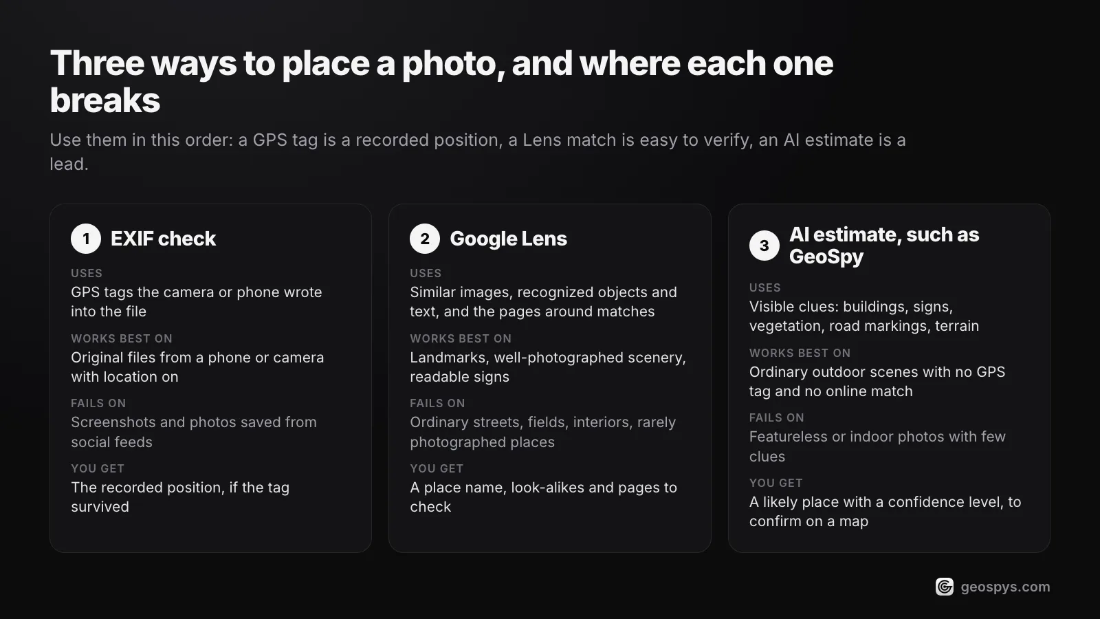
Use them in order. An EXIF check comes first, because a GPS tag is a recorded position. Lens comes next, because a named landmark or a page showing the same scene is easy to verify. An AI estimate is for what is left: ordinary scenes with no tag and no match, read as a lead, not proof.
| Method | What it uses | Works best on | Fails on | What you get |
|---|---|---|---|---|
| EXIF check | GPS tags the camera or phone wrote into the file | Original files from a phone or camera with location turned on | Screenshots, and photos saved from social feeds | The recorded position, if the tag survived |
| Google Lens | Similar images on the web, recognized objects, text, and the pages around matching images | Landmarks, well-photographed scenery, published photos and readable signs | Ordinary streets, fields, interiors and rarely photographed places | A place name, look-alike images and pages to check |
| AI location estimate, such as GeoSpy | Visible clues: buildings, signs, vegetation, road markings and terrain | Ordinary outdoor scenes with no GPS tag and no online match | Featureless or indoor photos with few clues | A likely place with a confidence level, to confirm on a map |
The three fail on different photos, which is why they combine well. A screenshot of a famous square has no GPS tag, but Lens may well name it. A phone photo of a quiet lane has no match online, but its tag may still be there. A reposted picture of a village street has neither, and the clues in the frame are all that is left. How AI geolocation works explains how a model reads those clues.
How do you combine Lens, EXIF and an AI estimate?
Check the file for GPS first. Then search the whole photo with Lens, crop to the most distinctive detail and search again, and read or translate any text. If nothing names the place, get an AI estimate. Confirm every candidate in Google Maps and Street View before you rely on it.
- Step 1Check the file for GPSOpen the original in your phone’s photo app or your computer’s file properties and look for coordinates. If they are there, you have your answer, and the rest is confirmation.
- Step 2Run Lens on the whole imageOn a computer, go to google.com, click Search by image and upload the file. In Chrome you can also right-click an image on a page and choose Search with Google Lens, which opens the results in a side panel. Read the pages that carry the same or a similar picture, not just the first label.
- Step 3Crop and search againDrag the selection box around one detail at a time: a tower, a sign, a shopfront, a mountain ridge. Each crop can lead somewhere different, and Google says a smaller area gives more specific results.
- Step 4Read the textUse Lens to copy or translate signs and menus. A business name or street name is often the fastest route to a place. Search it, or select an address in Lens on Android or iPhone to open it in Maps.
- Step 5Get an AI estimate for what is leftIf Lens returns only look-alikes, the scene has probably not been photographed and posted much. An AI estimate reads the clues instead. The GeoSpy extension adds Find where this photo was taken to Chrome’s right-click menu and shows the place, a confidence percentage and a map in the side panel.
- Step 6Confirm on the mapTreat every answer, from Lens or from AI, as a candidate. Find the spot in Google Maps and Street View and match several independent details. Street View is dense in some countries and thin in others, so check where it has coverage first.
GeoSpy – Photo Location Finder is free to install from the Chrome Web Store. Photo analysis needs a geospys.com account with GeoSpy Premium, at US$7.99 a week or US$29.99 a year. If a JPEG still carries GPS data, the answer comes from that. Otherwise you get an AI estimate from the visible clues, with a confidence percentage. The extension can only talk to geospys.com and reads nothing until you right-click an image. The extension page has the details.
An estimate is a lead, not a fact, and GeoSpy is no exception. When a photo shows no usable clues, GeoSpy on geospys.com says that no location was found.
Can someone use Google Lens to find where you are?
Lens is not built for that. Google says Lens uses your location, if you agree, to give you more accurate results. The real exposure is your photos: anyone can run a picture you post through Lens, and a recognizable backdrop, a street sign or a house number can give the place away.
As for your own searches, Visual Search History, the setting that saves the images you search with to your Google Account, is off by default. When you use Lens on a web page in Chrome, a screenshot of the page and page data go to Google, which says it keeps them only temporarily to answer the query and does not use them for training.
Faces are a separate question. In its help page for Lens in YouTube Shorts, Google says Lens does not use biometric facial recognition, although well-known public figures can appear in results. Lens is a tool for places and objects. That is exactly why the background of a photo can matter more than the face in it, as a selfie taken at home shows.
Frequently asked questions
- Can Google Lens tell where a screenshot was taken?
- Only from what the screenshot shows. Lens accepts screenshots like any other image, but a screenshot is a new file without the original photo’s GPS position (why). Any place Lens finds comes from a landmark, text or matching pages.
- Does Google Lens use my location?
- It can, if you agree. Google says Lens uses your location to return more accurate results when it identifies places and landmarks, so a person in Paris gets the Eiffel Tower rather than a look-alike. That describes where you are, not where an old photo was taken.
- Is Lens in Google Maps the same as Google Lens?
- No. Lens in Maps is a live camera view for finding your bearings outdoors, using the buildings and signs around you to pin down where you are standing. Google says it works only where Street View has coverage, in select countries, on phones that support ARCore or ARKit.
- Why does Google Lens show similar places instead of the right one?
- Because it ranks pictures by visual similarity, and many places share the same kinds of buildings, rides and coastlines. Bellingcat saw Lens tend to fixate on common structures in cities. Select a smaller, distinctive area such as a sign, and try a second engine.
- Can Google Lens find a person’s location from a photo?
- Lens is not built to identify people. Google says Lens does not use biometric facial recognition, although well-known public figures can appear in results. It can still recognize the place behind someone, which is why using it to locate a private person is misuse.
- Is the GeoSpy Chrome extension free?
- Installing it is free. Photo analysis is part of GeoSpy Premium, at US$7.99 a week or US$29.99 a year, and needs a geospys.com account.
Sources
- Search with an image on Google — Google Search HelpThe four kinds of Lens results, Search by image on a computer, the Chrome right-click option and the tip to select a smaller area.
- How Google Lens works (archived 19 September 2026) — Google, via the Internet ArchiveRanking by similarity and relevance, metadata on the image’s host site, the 95% German shepherd example and Lens’s use of your location. The live address now redirects.
- Get info about your photos & surroundings — Google Search HelpLens in Google Photos; a landmark or building returns historical facts or hours of operation.
- Region selection in Lens — Google Search HelpSelecting text in Lens on Android and iOS, including a Maps action for a selected address.
- Lens — Google SearchLandmarks, murals and artwork; translating text from over 100 languages.
- Find Google Image details — Google Search HelpImage details come from IPTC fields, structured data, C2PA and SynthID; no location field is listed.
- Learn more about an image — Google Search HelpAbout this image: available in some regions; when Google first saw an image and which pages use it.
- Learn about information stored on your photos — Google Photos HelpIPTC AI info and SynthID watermarks surfacing in Search and Lens through About this image.
- Search with Google Lens in Chrome — Google Chrome HelpA page screenshot and page data are sent to Google, stored only temporarily and not used for training; follow-up questions open AI Mode.
- Manage your Visual Search History in your settings — Google Search HelpThe Visual Search History setting is off by default.
- Use Lens in Google Maps — Google Maps HelpA live camera feature for areas with Street View coverage, in select countries, on ARCore or ARKit devices.
- Use Google Lens while watching a YouTube Short — YouTube HelpNo biometric facial recognition with Lens; results may show notable public figures.
- AI in Search: Going beyond information to intelligence — Google (The Keyword)May 2025: more than 1.5 billion people use Lens every month.
- Ask questions in new ways with AI in Search — Google (The Keyword)October 2024: nearly 20 billion visual searches with Lens every month.
- Have LLMs Finally Mastered Geolocation? — BellingcatJune 2025: 500 tests, 20 models and 25 unpublished photos, compared with the first 10 Lens visual matches; the Schluchsee, Zurich and Singapore tests.
- LLMs Vs. Geolocation: GPT-5 Performs Worse Than Other AI Models — BellingcatAugust 2025 retest of 24 models: Google AI Mode the most capable, but still sometimes confidently wrong.
Keep reading
Google Lens vs Yandex: Which Finds Places Better?
Two engines that fail on different photos. Which one to reach for when the subject is a building, a product, a landmark or an ordinary street.
· 4 min read
How to Find GPS Coordinates in a Photo
Read the exact latitude and longitude stored inside a geotagged photo, understand the degrees-minutes-seconds format, and know how far to trust the numbers.
· 4 min read
How Does AI Geolocation Work?
An AI geolocation model does not look anything up. It reads the same visual evidence a trained human would, and its limits follow directly from that.
· 4 min read
How to Reverse Image Search on Chrome: Lens, Bing and TinEye
Right-click any picture in Chrome to search it with Google Lens. The exact menu names on each device, why the option vanishes, and how to add Bing or TinEye.
· 9 min read