
Find Location From Photo With AI: Upload a Picture
Upload a picture to locate it
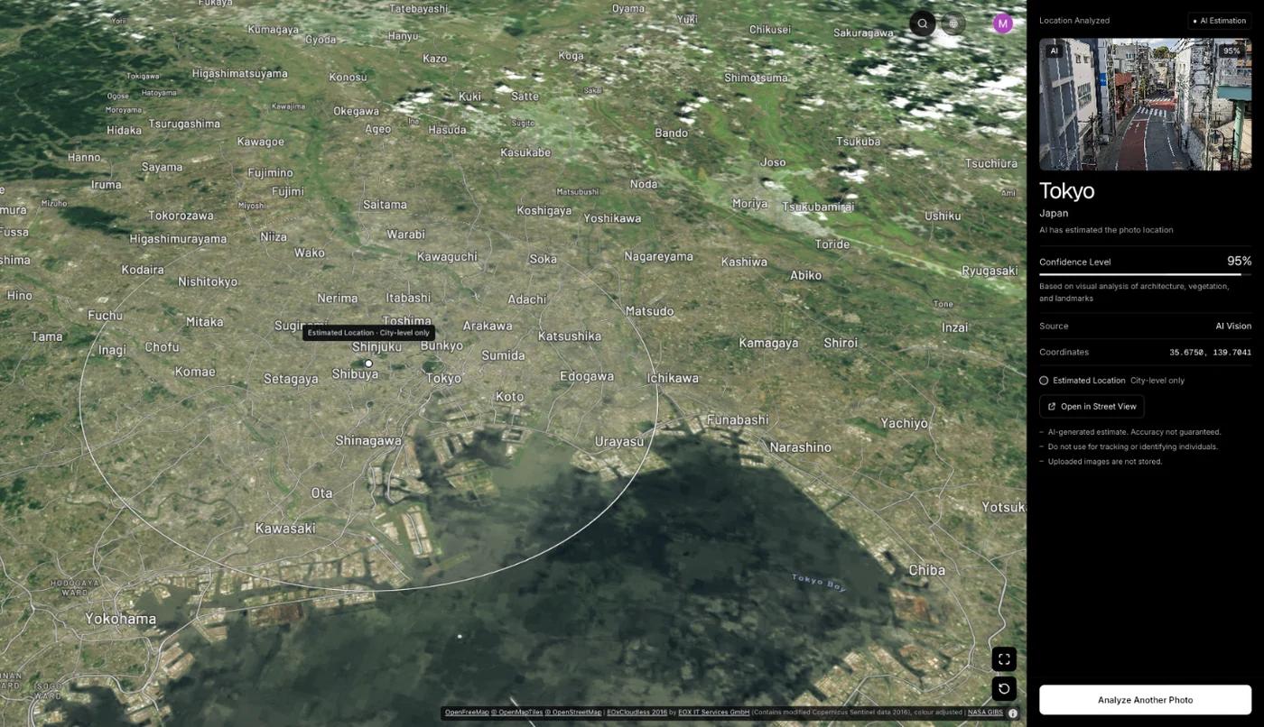
GeoSpy AI reads the GPS in the file if there is any, and otherwise estimates the location from the scene: buildings, signs, roads, plants and light.
By Sam D. · · 4 min read
Short answer
To find a location from a photo with AI, upload it to an AI geolocation tool. The model compares what it sees, such as architecture, road markings, plants and light, with patterns learned from photos of known places, and returns the most likely city or region. If the photo still has GPS data, that comes first and is exact.
How does AI find a location from a photo?
It reads the visible evidence in the picture and weighs it against what it learned from images of known places, then names the most likely area with a confidence score.
A geolocation model is trained on very large collections of photos whose locations are known. It learns which combinations of details go together: the script on a sign with a style of street lamp, a kind of roof with a kind of tree. Shown a new photo, it scores places by how well they fit. How AI geolocation works goes deeper into the method.
What can AI read in a photo?
Text and script, road markings, architecture, vegetation, the light and the small street furniture people overlook. Each narrows the possibilities a little.
| Clue in the photo | What it narrows down |
|---|---|
| Script and language on signs | The country or the language region |
| Road markings and the side cars drive on | The country |
| Architecture and building materials | The region and its climate |
| Trees, grass and crops | The climate zone |
| Sun angle and shadows | The hemisphere and roughly the latitude |
| Poles, bollards and plates | The country, often precisely |
People who play location games learn the same list, from the shape of a shadow to bollards and road signs. The model reads all of them at once, which is why a street with nothing famous on it can still be placed.
How accurate is AI photo geolocation?
Good at regions and often right about cities when the scene is distinctive; weak on generic scenes. No model gives addresses from a picture alone.
Published research sets the expectation. PIGEON, a Stanford model presented at CVPR 2024, placed 40.36% of its test images within 25 km of the true location, with a median error of 44.35 km. Among the sample results shown on this site, a San Francisco street of Victorian row houses with no GPS in the file was placed in San Francisco, USA, with 100% confidence, and photos from Kyoto and the Grand Canyon with 95%.
When is GPS better than AI?
Whenever the file still has it. GPS coordinates are a measurement accurate to a few metres; an AI estimate is an inference about a whole area.
A photo straight from a phone often still carries its GPS coordinates, and a smartphone fix is typically accurate to about five metres. The AI route is for everything else: photos from social media and messaging apps, which strip the data, and pictures saved from the web. Finding a photo’s location without EXIF compares the routes.
Which photos can AI not locate?
Indoor scenes, close-ups, plain landscapes with nothing regional in them, and heavily edited images. A confident answer on one of these deserves doubt.
- Rooms and interiors, which look much the same everywhere.
- Close-ups of objects, food or faces.
- Open sea, sky, snowfields or desert with no landmarks.
- Images that have been cropped, filtered or generated; check whether a photo is real first.
On the website, photo analysis comes with a weekly or yearly subscription that you can cancel any time, or a one-time purchase for a single photo; the GeoSpy iPhone app has a free trial. How the photo location finder works has the details.
Frequently asked questions
- Can AI tell where a photo was taken?
- Often, to the city or region, when the scene has distinctive buildings, signs or landscape. It cannot give an exact address from the picture alone.
- Is there an AI that finds a location from a picture?
- Yes. GeoSpy AI estimates the city and country from what a photo shows, after checking the file for GPS coordinates. Research models such as Stanford’s PIGEON do the same.
- Can ChatGPT find where a photo was taken?
- General chat assistants can describe clues and guess a place, sometimes well. How far ChatGPT gets is covered in its own guide.
- How do I find the location of a photo without GPS?
- Read the scene: signs, architecture, road markings and vegetation, by hand or with an AI geolocation tool, and try a reverse image search in case the photo was published with a caption.
- Is it free?
- On this website, photo analysis comes with a subscription of 9.99 US dollars a week or 39.99 a year, or 1.99 US dollars once for a single photo; the GeoSpy iPhone app has a free trial.
Sources
- PIGEON: Predicting Image Geolocations — arXiv — Haas, Skreta, Alberti and Finn40.36% of test images within 25 km; 44.35 km median error.
- GPS Accuracy — GPS.govSmartphones are typically accurate to within 4.9 m under open sky.
Keep reading
How Does AI Geolocation Work?
An AI geolocation model does not look anything up. It reads the same visual evidence a trained human would, and its limits follow directly from that.
· 4 min read
Can ChatGPT Tell Where a Photo Was Taken?
Often, yes. In Bellingcat’s tests, three ChatGPT models beat Google Lens. How close it gets, when it reads GPS data or your IP instead, and where it fails.
· 11 min read
How to Find Photo Location Without EXIF Data
The metadata is gone, so what is left? Three approaches that work on a stripped photo, what each realistically achieves, and where they stop.
· 5 min read
How to Find Location From Shadows in a Photo
Shadows will not give you a country, but they settle hemisphere, time of day and season — which is often exactly what separates two candidate answers.
· 4 min read