
Where Is This Building? 7 Clues That Give Its Location Away
By Sam D. · · 7 min read
Short answer
To work out where an ordinary building is, read seven clues: architectural style, building materials, roof pitch, window and door design, signage language and script, street furniture, and what the climate and vegetation imply. Together they usually narrow a photo to a country or region before any search.
Find where your photo was taken
Upload a photo: GeoSpy AI reads its GPS data if it has any, and otherwise estimates the place from what it shows.
Famous landmarks are easy: you search the name. Most buildings in photographs are not famous. They are a corner shop, a block of flats, a farmhouse or a row of terraced houses, and nobody has written about them. For those, the building itself is the evidence, and it tells you more than people expect. If your building is a recognizable monument, use how to identify a landmark from a photo instead.
Think of the seven clues below as filters. No single one is conclusive, because builders copy styles across continents. But each removes part of the map, and where several agree the region becomes clear.
What does a building’s architectural style tell you?
Style reveals the period and often the culture that built it. Victorian terraces, Mediterranean stucco villas, Soviet-era panel blocks and Japanese timber houses each cluster in particular places. A style narrows the region, but because styles travel, confirm it with other clues.
Start with the overall form: how tall, how wide, how it sits next to its neighbors. Narrow townhouses sharing walls suggest an old dense city centre. Detached houses on large lots suggest suburbs. Low flat-roofed blocks in light colors suggest a hot dry region. Style is a hint about origin and era rather than a pin on a map, since colonial and modernist architecture appear worldwide.
Which building materials point to a region?
Materials follow local supply and climate. Red brick, stone, adobe, timber, corrugated metal and concrete block each suggest different places. Look at walls, roofing and fences, and note whether the material looks locally available or imported.
- Wood siding and shingles suggest forested regions with cold winters, such as much of North America and Scandinavia.
- Stone walls appear where stone is plentiful, such as parts of the Mediterranean and uplands in Britain.
- Adobe or rendered mud brick suggests dry regions.
- Corrugated metal roofing is common in rainy tropical and rural areas.
- Exposed concrete and cinder block point to places where cost and speed mattered most.
How does roof pitch show the climate?
Steep roofs shed snow and heavy rain, so they cluster in cold or wet regions. Shallow or flat roofs suit dry climates where little water runs off. Overhanging eaves and covered verandas point toward hot, sunny or monsoon areas.
Roofs are one of the most readable parts of any building photograph. A steep gable with no overhang is a snow-country shape. A low pitch with wide eaves is built to shade walls from the sun. Flat roofs with parapets are typical of dry regions, and tiled roofs in clay red have strong regional associations. Look also for chimneys and the number of them, which tell you how people heat the building.
What can windows and doors reveal?
Windows reflect climate and local tradition: shutters in hot or windy places, small deep windows in cold ones, double-hung sashes in older British and American houses. Door styles, balconies and window bars add further regional character.
Shutters are common in southern Europe and parts of the American South. Window bars and grilles suggest a security culture. External roller shutters, double glazing and window air-conditioning units each narrow the era and region. Even the way windows open, inward or outward, varies by country.
Can the language and script on signs locate a building?
Yes. Text on signs names a language, and the script, spelling and format narrow it further. Business names, phone number formats, road sign shapes and house number styles can each point to a country. Even a few readable letters are worth searching.
Check scripts first: Latin, Cyrillic, Arabic, Greek, Thai or Chinese characters each remove most of the world. Then look closer. Latin-script languages share letters but differ in accents. Prices, units and phone-number formats help too. Our country-clues guide lists signs, plates and road markings by country.
What does street furniture say about a place?
Items such as utility poles, bollards, mailboxes, street lamps, fire hydrants and traffic lights follow national standards. Their shape, color and material are often distinctive enough to identify a country, sometimes even a city, from a small corner of an image.
Utility poles are a good example. Most utility poles are wood, pressure-treated with a preservative, yet pole height, crossarm layout and the use of concrete or steel vary a lot between countries. Mailbox style, crosswalk paint, and the color of curb markings also vary by country. These details matter because they sit beside the building in many photos, and they are rarely changed to suit a style.
How do climate and vegetation help?
Plants and light tell you the climate zone. Palms, conifers, cacti, bare deciduous trees or irrigated lawns each exclude regions. The Köppen system divides the world into five main climate groups, which gives a useful framework for narrowing a scene.
The Köppen system divides Earth’s climates into five main groups: tropical, arid, temperate, continental and polar. Match the vegetation and building shape to one of them first, then refine. Palms next to flat roofs point to a warm dry region, while snow guards on a steep roof point to a cold one. Remember that gardens can import plants, so use vegetation to support the other clues, not to lead.
How do you put the clues together?
List every clue in the picture, give each a region it supports, and look for overlap. Then test the shortlist with reverse image search and map imagery. If an AI estimate agrees with your reading, confidence goes up; if it differs, re-check the weakest clue.
Write the clues down, then rank them by how hard they are to fake. Script and street furniture are strong. Style and vegetation are weaker. Run the picture through a reverse image search in case it was published with a caption, and compare candidates in Street View, remembering that coverage is uneven.
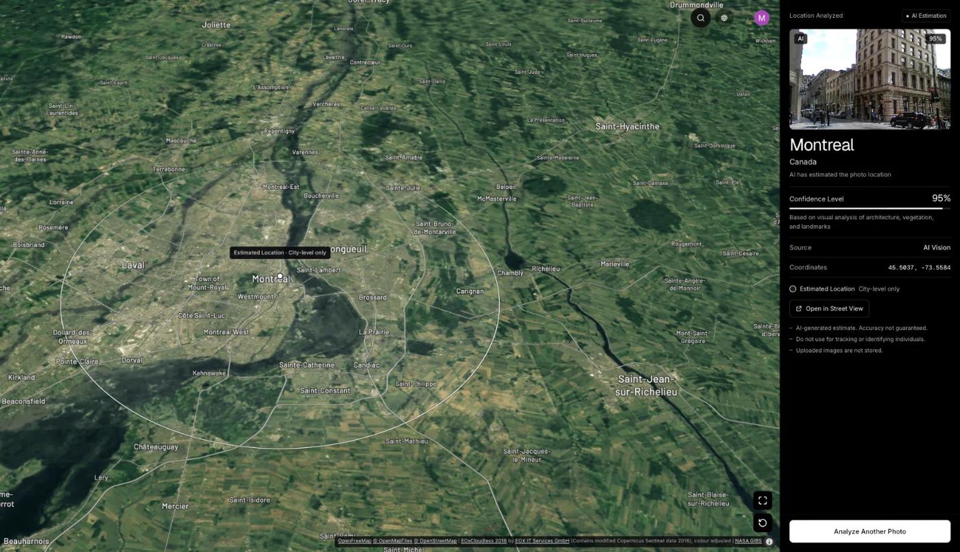
GeoSpy can serve as a cross-check. It reads GPS from the file’s EXIF data if present, and otherwise an AI model estimates the city and country from what the image shows, including architecture, signs, vegetation and light. The result is shown on a map with a confidence score: the point it found, with its coordinates, when the AI is highly confident, and otherwise an approximate area. On its site, a San Francisco street photo of Victorian row houses with no GPS data came back as San Francisco, USA at 100% confidence. Try it at the photo location finder. Web analysis needs a subscription ($9.99 a week or $39.99 a year, cancel any time) or $1.99 once for a single photo, and the iPhone app has a free trial. If you want the wider walkthrough, see how to find where a photo was taken.
Frequently asked questions
- How can I find out where a building is from a photo?
- Read its style, materials, roof, windows, any signs and the street furniture around it. Combine the clues to find a region, then check with reverse image search and Street View.
- Can I identify an unknown building with Google Lens?
- Google Lens works well for famous buildings and sometimes matches published photos. For an ordinary house or shop it often returns only similar-looking buildings, so combine it with clue reading.
- What country is this building in?
- Start with the script on any signs, then street furniture such as poles, mailboxes and road markings, which follow national standards. Style and climate clues then confirm or refine the guess.
- Can AI tell where a building photo was taken?
- An AI model can estimate a city or country from visible architecture, signs and vegetation, with a confidence score. It is an estimate, not an address, so verify it against map imagery.
- Why do buildings in different countries look alike?
- Styles and materials spread through trade, colonial history and modern construction. That is why you should never rely on architecture alone and should combine it with script, street furniture and climate.
Sources
- Köppen climate classification — WikipediaDivides Earth’s climates into five main groups: tropical, arid, temperate, continental and polar.
- Utility pole — WikipediaMost utility poles are wood, pressure-treated with a preservative; materials and layouts vary by region.
Keep reading
How to Identify a Landmark From a Photo
Name a landmark or building from a picture with Google Lens, iPhone Visual Look Up, Bing or Yandex, and what to do when the building is not famous.
· 12 min read
How to Identify a Country From Photo Clues
Regulated things beat natural things. The clues that change abruptly at borders, ordered by how much each one narrows the search and how fast you can read it.
· 4 min read
How Does AI Geolocation Work?
An AI geolocation model does not look anything up. It reads the same visual evidence a trained human would, and its limits follow directly from that.
· 4 min read
Google Street View Coverage: Where It Exists and Where It Doesn’t
Coverage is not a map of the world, it is a map of where a car could drive and a government allowed it. Which gaps exist, and why they matter for geolocation.
· 4 min read
What Is This Statue? How to Identify Statues and Monuments
What is this statue? Read the inscription on the base, identify the figure, check public art catalogs and run an image search to name it and find its place.
· 7 min read
How to Identify a Bridge From a Photo
What bridge is this? Name its type, count spans and towers, read its color and setting, then check bridge databases and satellite view to name the bridge.
· 6 min read