
How to Find Where a Landscape Photo Was Taken
By Sam D. · · 6 min read
Short answer
To find where a landscape photo was taken, check the file for GPS first. Without it, identify the skyline with a peak-identification tool such as PeakFinder or PeakVisor, read vegetation and sun direction for region and latitude, then match the view in Google Earth’s 3D terrain and confirm the candidate.
Find where your photo was taken
Upload a photo: GeoSpy AI reads its GPS data if it has any, and otherwise estimates the place from what it shows.
Landscapes look hard because they have no signs, no buildings and no text. But terrain is among the most permanent evidence a photograph can hold. A building can be demolished; a ridgeline is the same today as it was for the last ten thousand years. That is why mountains and coastlines can be matched with a precision that city scenes cannot.
This article covers the specific methods for natural scenes. For the general process, see how to find where a photo was taken. If the picture includes a famous peak or monument, identifying a landmark from a photo may already answer it.
Does the photo file already say where it was taken?
Possibly. Phone photos often carry GPS coordinates in EXIF, and a viewer can read them in seconds. Copies from social platforms and messaging apps have usually lost them, so check the original file first before any detective work.
Open the original image in an EXIF viewer and look for GPS fields. If they are there, you are done, subject to a sanity check that the coordinates fit the scene. If not, photos lose location tags when shared, and you move on to the picture itself.
How do you identify mountains in a photo?
Use a peak-identification tool. PeakFinder generates a labeled panorama from a viewpoint you choose, and PeakVisor can import a photo and name the peaks in view. Compare the skyline silhouette with the rendered panorama until the ridges line up.
PeakFinder’s website shows the peaks visible from a chosen viewpoint and exports the result as a printable SVG or a horizon file. PeakVisor describes a Photo Import feature that returns names and altitudes of peaks in view, plus augmented-reality identification on a phone. Neither tool can search the whole planet for your photo. You give them a candidate viewpoint, and they tell you whether the skyline matches, which means you first need a region.
- Step 1Guess a regionUse vegetation, climate and any other clue to choose a mountain range or country.
- Step 2Pick a plausible viewpointPhotos are usually taken from valleys, roads, lakes, towns and trails, not from random points.
- Step 3Render the panoramaOpen the view in PeakFinder or PeakVisor and compare the skyline.
- Step 4Match distinctive featuresLook for unusual notches, twin summits, cliffs and snow patterns, not the overall outline alone.
- Step 5Move the viewpointIf the peaks are right but the spacing is off, shift left, right, closer or farther until the gaps match.
Can the sun and shadows give away the latitude?
Roughly. Shadow length and direction tell you the sun’s height and bearing, which narrow latitude and time of day. They cannot pin a spot alone, but combined with the season and terrain they remove large parts of the globe.
A long shadow means a low sun, which means early or late in the day or a high latitude. Which side of a valley is lit helps work out compass direction. Our guide to finding location from shadows walks through the measurements, and the sun angle calculator turns a measured shadow, the date and the clock time into the latitudes it fits. Treat sun clues as a filter and not a coordinate.
What do vegetation and landforms say about the region?
Plants and landforms indicate a climate zone and often a continent. Desert scrub, alpine meadows, tropical forest, volcanic cones, glacial valleys and sea stacks each belong to particular regions. Use them to choose where to look before you search for the exact viewpoint.
The Köppen system divides Earth’s climates into five main groups: tropical, arid, temperate, continental and polar. Decide which group the scene belongs to first. Look at the tree line, since the altitude where trees stop shifts with latitude. Look at the rock: red sandstone, black volcanic rock and white limestone cliffs suggest different places. Water helps too. A gravel-bed braided river is a very different sign from a slow lowland one. Plants can be misleading in gardens and plantations, so prefer wild vegetation.
| Clue | What it narrows |
|---|---|
| Snow-capped serrated peaks | Young mountain ranges, many at high altitude |
| Tree line visible on slope | Latitude and altitude |
| Red or layered sandstone | Arid plateaus and canyon regions |
| Black volcanic rock and cones | Volcanic zones and island arcs |
| Palms with white sand | Warm coasts at low latitude |
| Drifting sea fog and dark rock coast | Cool cold-current coasts |
Can AI estimate where a landscape photo was taken?
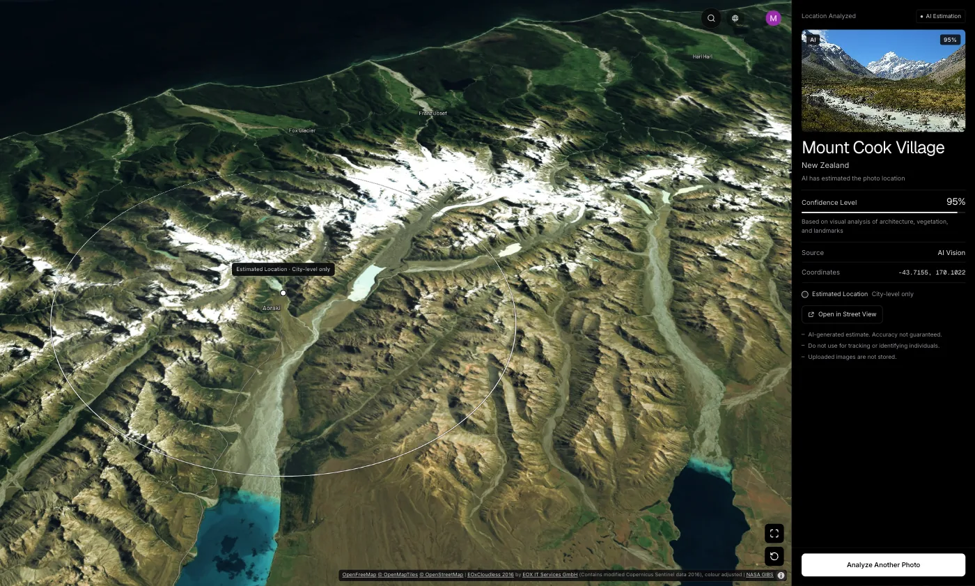
It can give a region. GeoSpy first reads GPS from the file if present, otherwise an AI model estimates the city and country from what the image shows. The result is shown on a map with a confidence score: the point it found, with its coordinates, when the AI is highly confident, and otherwise an approximate area.
Landscape photos give an AI less to work with than city streets, but distinctive terrain still counts. On the GeoSpy site, the Grand Canyon sample returned at 95% confidence. Those are sample results shown on the site, not a promise for every scene. A useful workflow is to run the photo through the photo location finder to choose your region, then use PeakFinder or PeakVisor to pin the viewpoint. Web analysis needs a subscription ($9.99 a week or $39.99 a year, cancel any time) or $1.99 once for a single photo, and the iPhone app has a free trial. For how these models reason, see how AI geolocation works.
How do you confirm the viewpoint in Google Earth?
Open the candidate area in Google Earth’s 3D view, move the camera to ground level and align it with the photo’s skyline. Match ridge shapes, lakes and coastline bends. If a dozen features line up from one spot, you have your location.
Once a candidate emerges, use Google Earth’s 3D terrain to stand where the photographer stood. Lower the camera, face the right bearing and compare. Google Earth also provides a timeline of historical imagery, which helps when a glacier, shoreline or lake level has changed since the photo was taken. Street View coverage can verify roadside viewpoints, though trails and summits are usually covered only by photo spheres.
Frequently asked questions
- How can I identify a mountain from a photo?
- Pick a likely region and viewpoint, then compare the skyline with a PeakFinder or PeakVisor panorama. Match distinctive notches and twin peaks, not the overall outline.
- Is there an app that tells you which mountain you are looking at?
- Yes. PeakFinder and PeakVisor both identify visible peaks from a viewpoint, and PeakVisor also offers augmented-reality identification on a phone and photo import.
- Can I find where a landscape photo was taken without GPS?
- Often, yes. Use vegetation and rock for the region, a peak tool for the skyline, and Google Earth 3D to confirm. It takes longer than a street scene because there are no signs.
- Does reverse image search work on landscape photos?
- Sometimes. It finds copies of published photos, but a private landscape shot usually has no match. Try it first, then fall back on terrain matching.
- Can the sun position tell me where a photo was taken?
- It narrows latitude and direction but cannot pin a spot alone. Combine it with season, terrain and vegetation.
Sources
- PeakFinder — PeakFinderShows peaks visible from a chosen viewpoint; exports printable SVG or a horizon file.
- PeakVisor — PeakVisorPhoto Import and augmented-reality peak identification.
- Köppen climate classification — WikipediaFive main climate groups: tropical, arid, temperate, continental, polar.
- View historical imagery in Google Earth — Google Earth HelpDescribes the timeline for past versions of a map.
Keep reading
How to Find Out Where a Photo Was Taken
Four ways to work out where a photo was taken: GPS metadata, reverse image search, AI geolocation and reading the image itself. What each can and cannot do.
· 7 min read
How to Find Location From Shadows in a Photo
Shadows will not give you a country, but they settle hemisphere, time of day and season — which is often exactly what separates two candidate answers.
· 4 min read
How to Identify a Landmark From a Photo
Name a landmark or building from a picture with Google Lens, iPhone Visual Look Up, Bing or Yandex, and what to do when the building is not famous.
· 12 min read
How Does AI Geolocation Work?
An AI geolocation model does not look anything up. It reads the same visual evidence a trained human would, and its limits follow directly from that.
· 4 min read
Where Is This Beach? How to Find a Beach From a Photo
Where is this beach? Read the sand, rocks, water, lifeguard flags and signs in the photo, then match the coastline on a map to name the exact beach.
· 7 min read