
How to Identify a City From a Photo
By Sam D. · · 9 min read
Short answer
Check the file for GPS first. If there is none, read the picture: skyline and landmarks, street signs and fonts, buses and trains, vehicle plates as regional hints, and vegetation. Narrow to a country, then a city, and confirm on a map. An AI estimate can speed up the shortlist.
Find where your photo was taken
Upload a photo: GeoSpy AI reads its GPS data if it has any, and otherwise estimates the place from what it shows.
You have a photo of a street, a harbor or a skyline, and one question: what city is this? Maybe it came from an old family album, a news post you are not sure about, or a trip where the camera roll lost its labels. The answer is rarely one dramatic clue. It is usually five small ones that point the same way.
This guide works at the city level. If you only need the country, our guide to country-level clues in a photo covers that, and when one famous building dominates the frame, see how to identify a landmark from a photo. Here the goal is the next step down: from "somewhere in Spain" to "this is Valencia".
Does the photo file already say what city it is?
Possibly. A photo straight from a phone with location access on often carries GPS coordinates in its EXIF data, which a viewer can read in seconds. Copies sent through messaging or social apps usually lose them, so check the original file before reading the scene.
Open the original image in any EXIF viewer and look for GPS latitude and longitude. If they are there, paste them into a map and you are done. If the file has been through a social app, why photos lose location when shared explains why they are gone, and finding a photo’s location without EXIF is the method that follows.
How do you read a skyline or landmark to name the city?
Match the overall silhouette, not individual buildings. Look for the tallest tower, the pattern of low and high blocks, a bridge, a river bend or hills behind the city. A silhouette that matches in three ways is far stronger than a similar-looking building.
Skylines change slowly and repeat in useful ways. A river curving through the frame, a ridge behind the towers, a cluster of identical blocks in one corner: all of these are geographic facts, and they can be checked on a map. Begin with the largest feature and work down.
- Tallest or most unusual building. Search a description ("glass tower with a pointed crown") rather than a name you do not know.
- Water and terrain. A harbor, a river with bridges or a mountain line is much harder to confuse than a building.
- Mix of old and new. A dense old core with a small tower cluster suggests different cities than uniform mid-rise blocks.
- Famous landmarks in the background. Even a small, distant tower can settle the question.
When a landmark is partly visible, use reverse search on a crop of it. Bellingcat’s geolocation technique on mapping landmarks describes building a reference set of landmarks for a region and comparing new footage against it. The tools it uses have changed since 2014, but the idea holds: know your candidate city’s signature shapes, then test.
What do street signs and fonts reveal about a city?
Signs give the language and often the exact place. Look for street names, shop names, bus-stop labels, phone area codes and postcodes. Even if you cannot read the script, the typeface, color and shape of a street sign help identify the country and sometimes the municipality.
Words are the strongest evidence in a photo because they can be searched. A shop name plus the word "pharmacy" in the local language often returns a list of branches, and a street name narrows it further. Read everything in the frame: delivery vans, ads on bus shelters, scoreboards, parking notices.
When the script is unfamiliar, use a camera translation app to read it, then search the name. Pay attention to design too. Street-name plates differ in shape, color and placement from country to country, and some cities have their own standard. Some regions and cities use their own style, which can help.
Can buses, trains and traffic point to a city?
Yes. Transit is local by design: bus liveries, tram shapes, taxi colors, metro entrances and ticket machines are often unique to a city or region. Which side of the road traffic uses also narrows the country, and you can search a photographed bus route number with the city name.
Public transport is among the best city-level clues, because operators brand it heavily. A photo with a yellow cab in the foreground and a particular style of subway entrance sends you somewhere very different from one with a green tram. Look at bus routes and numbers on destination boards: these can be matched against route maps. Road markings, signals and crossing patterns also differ between regions, even inside one country.
Vehicle plates as regional hints
Plates on parked cars can narrow a region, never identify an owner. Many countries use formats, colors or codes that indicate a region of registration, so a partial plate is only a clue to where the car was registered. A car can travel anywhere, so use plates as a hint to test against other evidence, never as a conclusion. Do not record or share plate numbers: crop or blur them before posting an image anywhere.
Which plants and weather help identify a city?
Vegetation separates climates: palms and bougainvillea suggest warm coasts, birch and pine suggest cooler latitudes, eucalyptus points to Australia or places where it was planted. Plants alone rarely name a city, but they quickly rule regions in or out and support other clues.
Look at the trees lining the street, the type of lawn, whether the hills are green or dry, and whether the sky has a hazy or crisp quality. Combine these with architecture: tile roofs and stucco in one place, brick and wood frame in another. The light helps as well. The sun’s direction and shadow length give a rough idea of latitude and time of day, which our guide to finding location from shadows explains.
How do you confirm a city on a map?
Pick your best candidate city, then find a spot where several fixed details line up: the same street layout, a bridge, a hillside, a recognisable storefront. Compare with satellite view and street-level imagery. Match at least three details before you say the answer is settled.
- Step 1List your cluesWrite down language, architecture, transit, plants, signs and any landmark. Keep strong clues (readable names) apart from weak ones (a tree).
- Step 2Make a shortlist of two or three citiesUse the strongest clue to select. If a photographed shop name is a chain, search its branch list.
- Step 3Test each against street-level imageryGoogle says Street View has captured over 220 billion images across more than 10 million miles, so many streets can be checked, though coverage is uneven.
- Step 4Look for something that contradictsOne mismatched detail, like a bridge that is not there, rules a candidate out. Absence of contradiction matters as much as agreement.
Google’s Street View anniversary page gives the 220 billion images and 10 million miles figures; for how much of your candidate city is covered, see our guide to Google Street View coverage. Where imagery is old, a newer storefront will not match, so compare structure rather than shop names.
What tools can tell you what city a photo is from?
Use them in layers: an EXIF viewer for GPS, reverse image search for published photos, and an AI geolocation tool for the rest. GeoSpy reads GPS if it exists, otherwise estimates the city and country from architecture, signs, vegetation and light.
| Situation | Try first | What you get |
|---|---|---|
| Original phone photo | EXIF viewer | GPS coordinates, if location was on |
| Photo that may already be online | Google Lens or Yandex | Matching pages that name the place |
| Private or never-published photo | AI geolocation | A city or region estimate with confidence |
| Photo with readable text | Search the text | Branches, street names, local listings |
| Single prominent building | Landmark search | Name of the building and its city |
GeoSpy AI shows its estimate on a map with a confidence score: the point it found, with its coordinates, when it is highly confident, and otherwise an approximate area. On the site, a San Francisco street photo of Victorian row houses with no GPS data returns San Francisco, USA at 100% confidence, and a sample from Kyoto returns Kyoto, Japan at 95%. Photo analysis on the website needs a subscription ($9.99 per week or $39.99 per year, cancel any time) or $1.99 once for a single photo; the GeoSpy iPhone app has a free trial; and a Chrome extension lets you right-click a photo online. The Street View guessing game on the site is free once a day if you want to practice reading cities first.
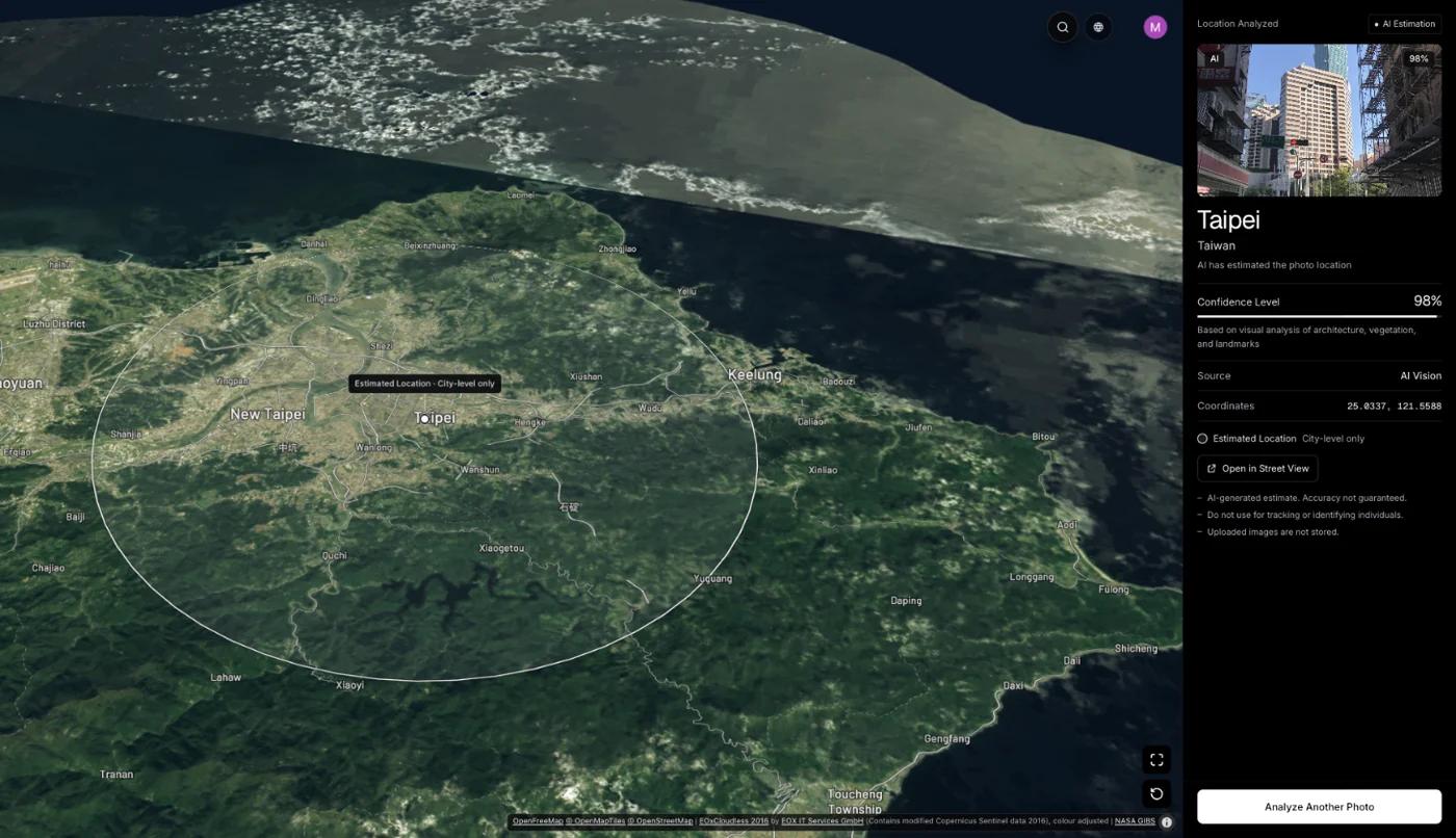
For the logic behind AI estimates, read how AI geolocation works, and for a step-by-step overview that is not city-specific, the guide to finding where a photo was taken is a good companion. As always, a score is a lead, not proof.
Frequently asked questions
- How can I tell what city a photo was taken in?
- Check the file for GPS data first. If there is none, read the image: skyline, landmarks, signs and fonts, transit, vegetation and architecture. Shortlist candidate cities, then confirm using satellite and street-level imagery.
- Can I find a city from a photo without GPS?
- Yes, if the picture shows enough. Readable signs, a distinctive skyline or recognizable transit can name the city. For photos with few clues, an AI geolocation estimate can produce a probable city to check, but it is not proof.
- What is the best app to identify a city from a picture?
- It depends on the photo. Reverse image search works for photos already online, an EXIF viewer for originals with GPS, and AI geolocation for the rest. GeoSpy’s iPhone app has a free trial, while website analysis needs a subscription or a one-time purchase for a single photo.
- Can a license plate tell you the city?
- Only loosely. Many countries encode a region in plate formats or codes, which can hint at where a car was registered, not where it was photographed. Use it as one clue among many, and never record or share plate numbers.
- How accurate is it to identify a city from a skyline?
- A skyline with a distinctive tower, river or hills can be very reliable when several features match. A generic row of towers is much weaker. Always confirm on a map rather than trusting a single resemblance.
Sources
- Celebrating 15 years of Street View — GoogleStates over 220 billion images and more than 10 million miles covered, across 100 countries and territories.
- Geolocation Techniques – Mapping Landmarks — BellingcatEliot Higgins, 2014. Building a reference set of landmarks to compare against new footage.
- A Beginner’s Guide to Geolocating Videos — BellingcatEliot Higgins, 2014. Using landmarks, road layout and satellite imagery, then checking for contradictions.
Keep reading
How to Identify a Country From Photo Clues
Regulated things beat natural things. The clues that change abruptly at borders, ordered by how much each one narrows the search and how fast you can read it.
· 4 min read
How to Identify a Landmark From a Photo
Name a landmark or building from a picture with Google Lens, iPhone Visual Look Up, Bing or Yandex, and what to do when the building is not famous.
· 12 min read
How to Find Photo Location Without EXIF Data
The metadata is gone, so what is left? Three approaches that work on a stripped photo, what each realistically achieves, and where they stop.
· 5 min read
How Does AI Geolocation Work?
An AI geolocation model does not look anything up. It reads the same visual evidence a trained human would, and its limits follow directly from that.
· 4 min read
Google Street View Coverage: Where It Exists and Where It Doesn’t
Coverage is not a map of the world, it is a map of where a car could drive and a government allowed it. Which gaps exist, and why they matter for geolocation.
· 4 min read