
How to Find Where an Old Photo Was Taken
By Sam D. · · 9 min read
Short answer
To find where an old photo was taken, look at the back for studio stamps and handwriting, then read the scene for signs, cars, buildings and terrain. Narrow the era, then compare with historical maps, aerial photographs and library archives, and ask local history groups. Verify any candidate on a modern map.
Find where your photo was taken
Upload a photo: GeoSpy AI reads its GPS data if it has any, and otherwise estimates the place from what it shows.
A shoebox of unlabeled prints is one of the most common starting points for a location search. Nobody wrote “Grandpa’s farm, 1958” on the back, and the people who knew are gone. The good news is that old photographs usually contain more evidence than modern ones: fewer filters, more signage, and buildings that were photographed because they were new.
The method below works from the physical object outwards. It starts with what you can hold, moves to what you can see in the scene, and ends with records that can confirm a guess. For a general introduction to locating any picture, see how to find where a photo was taken; this article is about the extra clues that only old photographs have.
- Inspect the print itself: back, borders, paper and format.
- Date the picture roughly from film, cars, clothing and signs.
- Read the scene for text, buildings, vegetation and terrain.
- Run an estimate to get a likely city or region.
- Compare with historical maps and aerials.
- Search library and archive collections.
- Check Street View and current imagery.
- Ask the people who know the place.
What can the back and edges of an old photo tell you?
Often the most. Photo studio stamps, lab marks, handwriting, dates and printed paper brands can name a town and a decade. Check the border style and print size too, because processing labs and formats changed in ways that narrow the period.
Turn the print over before anything else. A photographer’s stamp or embossed studio name is a direct lead: studios were local businesses, and a city directory or local historical society can often tell you where and when one operated. Look for a processing lab imprint, a numbered code, or a date stamp. Remember that a lab date often lags the exposure, because film sat in the camera for weeks before it was developed.
The format helps with dating. Kodak introduced 120 roll film for the Brownie No. 2 in 1901 and the narrower-spooled 620 in 1931, which it discontinued in 1995, so square snapshots with wide white borders point to the box-camera era. Match this with your other clues rather than trusting any single one, since forums disagree on exact dates for many formats.
| Clue | What it can tell you |
|---|---|
| Studio stamp or embossing | A town, and a rough operating period for the studio |
| Handwriting on the back | Names, a place or a date, even partial |
| Scalloped or deckled edges | A mid-century processing style, useful for narrowing the decade |
| Square format with wide borders | Often roll-film box cameras, roughly 1930s to 1960s |
| Lab stamp or code | A processing business, which may be traceable locally |
How do you date an old photo from what is in it?
Use objects with known production years: car models, clothing, street lamps, signage styles and utility poles. Each gives a range, and the overlap of several ranges gives a narrow window. A narrow window makes every later search, from maps to archives, far easier.
Vehicles are the most reliable. A car model identifies a year range in minutes with an enthusiast forum or reference book. Add clothing silhouettes, the style of storefront lettering, whether street lights are gas or electric, and whether there are overhead wires. Each item gives a window and your estimate is where the windows overlap. Do not rely on one object, because old cars stayed on the road for decades.
Where was this old photo taken: what clues in the scene give it away?
Signs and storefront names, building style and materials, road markings, vegetation and the shape of the land. A single readable word, such as a business name, can be searched in old directories. Terrain and plants narrow the region when there is no text at all.
- Text. Business names, street signs, church names, license plates, school banners. Zoom in on a scan at high resolution.
- Buildings. Roof shapes, materials, window styles and the way houses sit on lots point to regions. Reading ordinary buildings is covered in our country-clues guide.
- Landforms. A distinctive ridge, a river bend or a shoreline is often unchanged after a century.
- Vegetation. Palms, conifers, grassland or cultivated fields suggest a climate zone. Remember that trees you see may have been planted since.
- Shadows and light. In a photo with a visible shadow you can estimate time of day and latitude. See finding location from shadows.
Can AI estimate where an old photo was taken?
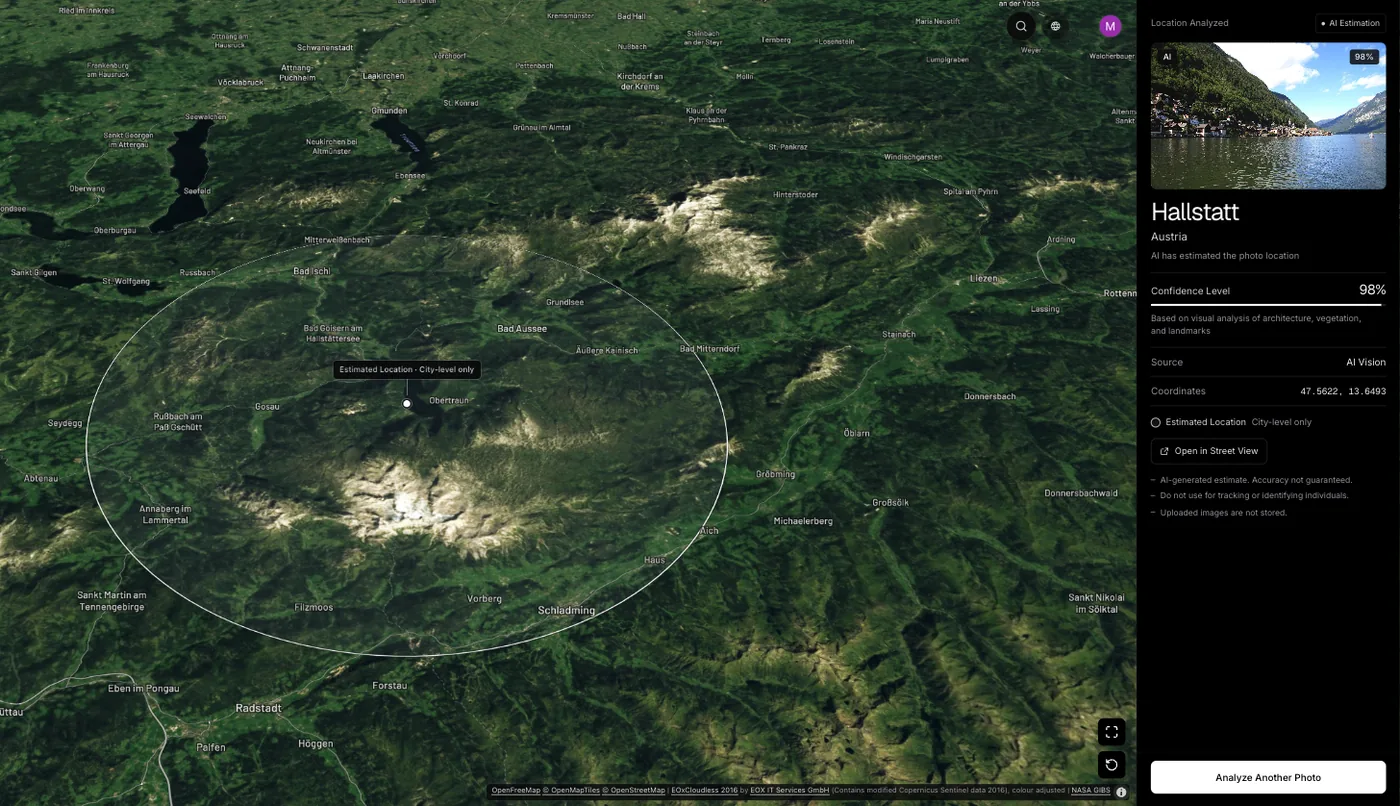
It can give a starting estimate. GeoSpy first reads GPS from the file if present, which scanned prints will not have, then estimates a city and country from what the image shows. It shows the point it found and its coordinates when it is highly confident, otherwise an approximate area, on a map with a confidence score.
Scanning a print creates a new digital file with no GPS data, so the estimate comes entirely from the scene. GeoSpy’s model looks at architecture, signs, vegetation and light. On its site, a San Francisco street photo of Victorian row houses with no GPS data was returned as San Francisco, USA at 100% confidence, and Kyoto, Japan and the Grand Canyon came back at 95%. Those are sample results from the site, not a guarantee for every photo, and older, grainier prints give the model less to read. Use it as one step: a way to pick which region to research first. You can try it at the photo location finder. Web analysis needs a subscription ($9.99 a week or $39.99 a year, cancel any time) or $1.99 once for a single photo, and the GeoSpy iPhone app has a free trial.
The wider logic is explained in how AI geolocation works, and finding a location without EXIF data covers what to do when metadata is simply not there. Scan at high resolution first, since small text and fine detail decide many cases.
How do historical maps and aerial photos confirm a location?
Once you have a candidate area, compare the scene with maps and aerials from the same era. USGS maps from 1884 to 2006 are free to browse, and the US National Archives holds more than 35 million aerial photographs dating from 1918 to 2011.
The USGS Historical Topographic Map Collection contains maps published from 1884 to 2006 and is browsable in TopoView. Use it to check road layouts, rail lines, rivers and building footprints for the decade of your photo. The National Archives holds over 35 million aerial photographs from 1918 to 2011, mostly federal agency work, and holds the aerials across several record groups. Archivists can search those by place. For parts of the world outside the US, national mapping agencies and city archives often run similar collections.
Google Earth also has a timeline of historical imagery, which helps once you reach the 1940s or later. Use it to see if a lot, a bend in a road or a row of buildings looked different decades ago.
Where can you search library and archive collections?
Start with public libraries and state or university digital collections for the region you suspect. Search by place name and decade. Many hold street photographs, postcards, fire insurance maps and city directories that match scenes closely.
- State and city digital collections, searchable by street or neighborhood.
- Historical society photo files, where a volunteer may recognise your building.
- Old postcards, which often show the same views as snapshots.
- City directories, to match a business name from a sign to an address and year.
- Newspaper archives for the place, to date a visible event or building.
Reverse image search occasionally matches a scanned print to an archive record, particularly for well-photographed streets. The tools compared differ in how well they handle black-and-white images.
Can Street View show how a place looked before?
Yes. Street View keeps older captures for many roads, so you can step back through past years, and Google Earth’s historical imagery goes further. Neither reaches the era of most family prints, so use them to confirm the place, not to match the scene exactly.
Once a candidate street emerges, walk it virtually. Match fixed features: the line of the street, a church tower, a hillside behind the houses. Expect change. Shopfronts and trees disappear while street layouts and hills stay. Where Street View has coverage varies, so older or rural locations may need aerial imagery instead.
Who can help you identify an old photo?
Local history groups, genealogy forums and regional subreddits are often the fastest route. Post the scan with the approximate era and region, say what you already know and ask what people recognise. Local residents notice things researchers miss.
Share the best scan, the dating clues you have gathered and the region you think it is. Do not post photos of living people with identifying detail. Relatives are another resource: show the picture to the oldest family members and ask what they remember about places, even if it was not this exact one.
Frequently asked questions
- How can I find out where an old family photo was taken?
- Check the back for studio stamps and writing, date the scene from cars and clothing, read any signs, then compare with historical maps and local archives. Local history groups can often recognise a building at once.
- Can I use reverse image search on an old photo?
- You can, and it occasionally matches a scan to an archive record, especially for well-photographed streets. Most private snapshots will have no match, so treat it as a cheap first try.
- How do I tell what year an old photo was taken?
- Combine several clues: car models, clothing, signage style, film format and print style. Each gives a range, and the overlap is your estimate. A processing date stamp may be later than the exposure.
- Do old scanned photos have GPS data?
- No. A scan is a new digital file with no location tags, because the original print never recorded any. Any location has to come from what the picture shows.
- Can AI tell where a black and white photo was taken?
- It can estimate a likely city or region from architecture and scene content, with a confidence score, but old grainy prints give it less to read. Treat the result as a lead and verify it against maps.
Sources
- Aerial Photography — U.S. National ArchivesOver 35 million aerial photographs dating from 1918 to 2011.
- Topographic Maps — U.S. Geological SurveyThe Historical Topographic Map Collection covers maps published 1884 to 2006.
- 120 film — WikipediaIntroduced 1901 for the Brownie No. 2; 620 introduced 1931 and discontinued 1995.
- View historical imagery in Google Earth — Google Earth HelpDescribes the timeline for past versions of a map.
Keep reading
How to Find Out Where a Photo Was Taken
Four ways to work out where a photo was taken: GPS metadata, reverse image search, AI geolocation and reading the image itself. What each can and cannot do.
· 7 min read
How to Find Photo Location Without EXIF Data
The metadata is gone, so what is left? Three approaches that work on a stripped photo, what each realistically achieves, and where they stop.
· 5 min read
How Does AI Geolocation Work?
An AI geolocation model does not look anything up. It reads the same visual evidence a trained human would, and its limits follow directly from that.
· 4 min read
Google Street View Coverage: Where It Exists and Where It Doesn’t
Coverage is not a map of the world, it is a map of where a car could drive and a government allowed it. Which gaps exist, and why they matter for geolocation.
· 4 min read
How to Find Location From Shadows in a Photo
Shadows will not give you a country, but they settle hemisphere, time of day and season — which is often exactly what separates two candidate answers.
· 4 min read