
We Tested an AI Photo Location Finder on 50 Photos (2026)
By Arthur L. · · 11 min read
Short answer
To measure AI photo location finder accuracy, we ran 50 public-domain photos with known locations through GeoSpy. 45 answers (90%) landed within 25 km of the true spot and 33 (66%) within 1 km. It named the right country 48 times and struggled most with generic roads and fields.
Tools that guess where a photo was taken make big claims, and few of them show their misses. So we ran a plain test on our own analyzer: 50 photos whose camera positions are on record, each uploaded once, every answer measured in kilometers from the true spot. This page has the numbers, the misses and all 50 results.
How accurate is an AI photo location finder?
In our 50-photo test, GeoSpy placed 45 photos (90%) within 25 km of where they were taken and 33 (66%) within 1 km. It named the right country 48 times. Generic roads and fields were its weak spot: 3 of 7 such answers were more than 25 km off.
The typical answer was very close: the median distance between GeoSpy’s pin and the camera was 0.4 km. The average, 33 km, is pulled up by one photo, a highway in Namibia that was placed 956 km away in South Africa.
| Distance from the true spot | Photos | Share |
|---|---|---|
| Within 1 km (street) | 33 of 50 | 66% |
| Within 25 km (city) | 45 of 50 | 90% |
| Within 200 km (region) | 47 of 50 | 94% |
| Within 750 km (country) | 49 of 50 | 98% |
| Within 2,500 km (continent) | 50 of 50 | 100% |
| Right country named | 48 of 50 | 96% |
How we ran the test
- Step 1Picked 50 photos with known positionsAll from Wikimedia Commons, public domain (19) or CC0 (31): 12 city streets, 8 landmarks, 8 nature or mountain views, 7 towns and villages, 6 coasts, 4 roads, 3 deliberately generic scenes and 2 interiors or close-ups, on six continents. For 22 the position comes from the camera’s own GPS, for 28 from the location the photographer set on the file’s page.
- Step 2Removed every clue but the pictureWe stripped all metadata (EXIF, XMP, IPTC) and re-saved each file at 1,600 pixels on the long side, so no GPS tag could give the answer away. GeoSpy reads a photo’s GPS first when it has one; without it, the AI has to work from what the picture shows.
- Step 3Asked once and kept the first answerEach photo went once through the same analysis the site’s Analyze button runs, signed in, on November 9 and 10, 2026. No retries, no hints, no cropping. The median answer took 10 seconds.
- Step 4Measured the distanceWe measured the great-circle distance from GeoSpy’s coordinates to the camera position and scored it against the 1, 25, 200 and 750 km bands used in geolocation research, plus 2,500 km for the continent.
Where did it find the exact spot?
Mostly at recognizable places, but not only there. All 8 landmarks landed within 25 km, at a median of 0.1 km, and so did 11 of 12 ordinary city streets, among them a block of Eighth Avenue in Manhattan (0.3 km) and a side street in Accra (0.6 km).
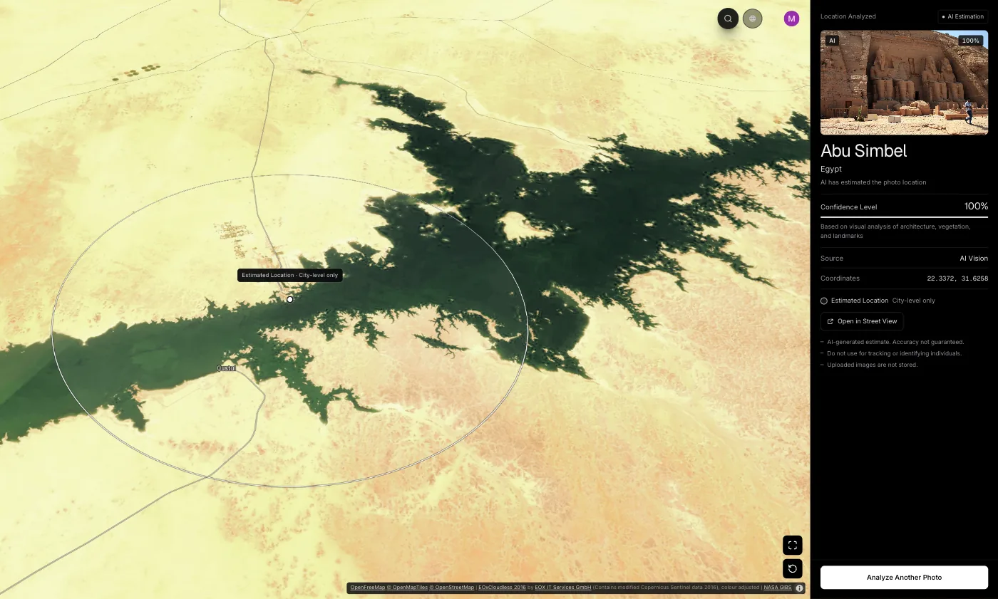
The closest answers included Abu Simbel, the Obelisco in Buenos Aires, the Avenue of the Baobabs in Madagascar and Moraine Lake in Canada, all within about 100 meters. Two photos showed the place’s name, a decorated manhole cover in Fujikawaguchiko and the sign on Flinders Street Station. We kept them because real photos often do, and without them the results barely change. To see how a guess is built from architecture, signs and plants, read how AI geolocation works; for famous buildings and monuments, see how to identify a landmark from a photo.
Where did it miss?
Five answers were more than 25 km off: a street in Kraków placed in Wrocław (236 km), a village in eastern Nepal placed in Langtang (230 km), a maize field in Nigeria (133 km), desert scrub in New Mexico (32 km) and a Namibian highway placed in South Africa (956 km).
The misses follow a pattern. Three were scenes that look alike across a whole region: a two-lane road through dry grassland, a field, desert scrub. The other two were confident mix-ups between neighbors, since old-town streets in southern Poland and villages in the Himalaya share a lot. One of the two “wrong country” answers was right to within a kilometer: the Zambezi just above Victoria Falls, which is the border between Zambia and Zimbabwe.
| Kind of scene | Photos | Median distance | Within 25 km |
|---|---|---|---|
| Landmark | 8 | 0.1 km | 8 of 8 |
| Coast or water | 6 | 0.3 km | 6 of 6 |
| Town or village | 7 | 0.3 km | 6 of 7 |
| City street | 12 | 0.4 km | 11 of 12 |
| Interior or close-up | 2 | 0.6 km | 2 of 2 |
| Nature or mountains | 8 | 0.9 km | 8 of 8 |
| Road or highway | 4 | 7.4 km | 3 of 4 |
| Generic scene | 3 | 32 km | 1 of 3 |
Does the confidence score mean anything?
Mostly, yes. Of 41 answers given with 90% confidence or more, 39 were within 25 km. Of the five given at 60% or less, only two were. But two confident answers, at 95% and 92%, were still about 230 km off, so treat the score as a hint, not proof.
The four answers in between, at 85%, were all within 25 km. In practice a low score is a good reason to check the answer on the map before you rely on it, and a high score usually, but not always, means the place is right.
What can’t a 50-photo test tell you?
How the tool does on your own photos. All 50 came from Wikimedia Commons, which is public and widely copied, and many show famous places, so an AI model may have seen some of them before. Unpublished photos of ordinary places will be harder: expect lower numbers.
Research points the same way. A 2025 study of 25 vision-language models found they do poorly on generic street-level images while reaching 61% accuracy on pictures that look like social media posts; the best model averaged 41.3% at city level and 77.5% at country level across its test sets. Our own ground truth has limits too: for 28 photos the camera position was pinned by hand on a map, so differences of a few hundred meters are within the noise.
How do you get a better answer from a photo location finder?
Upload the original file, keep the surroundings in the frame and check a low-confidence answer on the map. If the photo has been published online, run a reverse image search too.
- Upload the original file. If it still has GPS data, GeoSpy reads it first and names the place from it.
- Keep the context in the frame: skyline, signs, road markings and the landscape behind a person carry most of the clues.
- Avoid heavy crops, filters and screenshots of screenshots, which remove the small details the model reads.
- Treat a low confidence score as a starting point and check it on the map; the result has a Street View link.
- For a photo that may already be online, try reverse image search as well: it finds copies, while AI estimates the place. More methods are in finding a photo’s location without EXIF data.
All 50 results
Sorted from the closest answer to the farthest. The distance is from GeoSpy’s coordinates to the camera position on record.
| # | Photo (true place) | Scene | GeoSpy’s answer | Confidence | Distance |
|---|---|---|---|---|---|
| 1 | Flinders Street Station, Melbourne, Victoria (Australia) | Landmark | Melbourne, Australia | 100% | <0.1 km |
| 2 | Nave of St Giles’ Cathedral, Edinburgh, Scotland (United Kingdom) | Interior or close-up | Edinburgh, United Kingdom | 95% | <0.1 km |
| 3 | Plaza Mayor, Trinidad, Sancti Spíritus (Cuba) | Town or village | Trinidad, Cuba | 95% | <0.1 km |
| 4 | Avenue of the Baobabs near Morondava, Menabe (Madagascar) | Nature or mountains | Morondava, Madagascar | 98% | <0.1 km |
| 5 | Obelisco on Avenida 9 de Julio, Buenos Aires (Argentina) | Landmark | Buenos Aires, Argentina | 100% | <0.1 km |
| 6 | Great Temple of Ramesses II, Abu Simbel (Egypt) | Landmark | Abu Simbel, Egypt | 100% | <0.1 km |
| 7 | Plaza San Francisco, La Paz (Bolivia) | City street | La Paz, Bolivia | 98% | <0.1 km |
| 8 | Fanshawe Street, Auckland CBD (New Zealand) | City street | Auckland, New Zealand | 95% | <0.1 km |
| 9 | Beach at Padangbai, Bali (Indonesia) | Coast or water | Padangbai, Indonesia | 92% | 0.1 km |
| 10 | Moraine Lake and Valley of the Ten Peaks, Banff National Park, Alberta (Canada) | Nature or mountains | Banff, Canada | 98% | 0.1 km |
| 11 | Peggy’s Point Lighthouse, Peggy’s Cove, Nova Scotia (Canada) | Landmark | Peggy’s Cove, Canada | 99% | 0.1 km |
| 12 | Eguisheim, Alsace (France) | Town or village | Eguisheim, France | 98% | 0.1 km |
| 13 | Beach below the Tulum ruins, Quintana Roo (Mexico) | Coast or water | Tulum, Mexico | 98% | 0.1 km |
| 14 | Mont-Saint-Michel seen from the causeway, Normandy (France) | Landmark | Le Mont-Saint-Michel, France | 100% | 0.1 km |
| 15 | Atomium, Laeken, Brussels (Belgium) | Landmark | Brussels, Belgium | 100% | 0.2 km |
| 16 | Medina of Chefchaouen near the Kasbah (Morocco) | Town or village | Chefchaouen, Morocco | 95% | 0.2 km |
| 17 | Old Montreal near Place d’Armes, Montreal, Quebec (Canada) | City street | Montreal, Canada | 95% | 0.2 km |
| 18 | Cliffs near the Twelve Apostles, Port Campbell National Park, Victoria (Australia) | Coast or water | Port Campbell, Australia | 95% | 0.2 km |
| 19 | Market street in the medina of Essaouira (Morocco) | City street | Essaouira, Morocco | 92% | 0.2 km |
| 20 | Taipei 101 and Grand Hyatt seen from Keelung Road, Xinyi District, Taipei (Taiwan) | Landmark | Taipei, Taiwan | 98% | 0.2 km |
| 21 | Rua Augusto Rosa with tram 28, Alfama, Lisbon (Portugal) | City street | Lisbon, Portugal | 95% | 0.3 km |
| 22 | Town centre of Thames, Thames-Coromandel District, Waikato (New Zealand) | Town or village | Thames, New Zealand | 95% | 0.3 km |
| 23 | Wat Arun seen from the Chao Phraya River, Bangkok (Thailand) | Landmark | Bangkok, Thailand | 98% | 0.3 km |
| 24 | Eighth Avenue at 46th Street, Manhattan, New York City (United States) | City street | New York, United States | 95% | 0.3 km |
| 25 | Gokyo Lake and Ngozumpa Glacier from Gokyo Ri slope, Khumbu (Everest region) (Nepal) | Nature or mountains | Gokyo, Nepal | 95% | 0.4 km |
| 26 | Ollantaytambo, Sacred Valley, Cusco Region (Peru) | Town or village | Ollantaytambo, Peru | 98% | 0.4 km |
| 27 | Quang Trung Street area, Hanoi (Vietnam) | City street | Hanoi, Vietnam | 95% | 0.4 km |
| 28 | Danče Beach, Dubrovnik (Croatia) | Coast or water | Dubrovnik, Croatia | 95% | 0.4 km |
| 29 | Street in Osu, Accra (Ghana) | City street | Accra, Ghana | 90% | 0.6 km |
| 30 | Hallstatt seen from Lake Hallstatt, Upper Austria (Austria) | Town or village | Hallstatt, Austria | 98% | 0.8 km |
| 31 | Hooker Valley towards Aoraki / Mount Cook, Canterbury (New Zealand) | Nature or mountains | Mount Cook Village, New Zealand | 95% | 0.8 km |
| 32 | Zambezi River just above Victoria Falls, Mosi-oa-Tunya National Park, Livingstone (Zambia) | Coast or water | Victoria Falls, Zimbabwe | 85% | 1.0 km |
| 33 | Meadow in Yosemite Valley, Yosemite National Park, California (United States) | Nature or mountains | Yosemite Valley, United States | 95% | 1.0 km |
| 34 | Perito Moreno Glacier from the observation decks, Los Glaciares National Park, Santa Cruz (Argentina) | Nature or mountains | El Calafate, Argentina | 98% | 1.1 km |
| 35 | Decorated manhole cover, Fujikawaguchiko, Yamanashi (Japan) | Interior or close-up | Fujikawaguchiko, Japan | 95% | 1.3 km |
| 36 | Praia da Lagoinha do Leste, Florianópolis, Santa Catarina (Brazil) | Coast or water | Florianópolis, Brazil | 95% | 1.3 km |
| 37 | Street in Old Delhi, Delhi (India) | City street | New Delhi, India | 90% | 1.5 km |
| 38 | Road from Salento towards the Cocora Valley, Quindío (Colombia) | Road or highway | Salento, Colombia | 85% | 2.1 km |
| 39 | Interstate 5 near Yreka, Siskiyou County, California (United States) | Road or highway | Yreka, United States | 60% | 4.0 km |
| 40 | Forest path near Lohme, Rügen island, Mecklenburg-Vorpommern (Germany) | Generic scene | Sassnitz, Germany | 60% | 5.3 km |
| 41 | Street in Motoyoyogi near Yoyogi-Hachiman, Shibuya, Tokyo (Japan) | City street | Tokyo, Japan | 95% | 5.8 km |
| 42 | Avenida Brasil, Valparaíso (Chile) | City street | Viña del Mar, Chile | 98% | 6.9 km |
| 43 | Croda dei Toni (Zwölferkofel), Sexten Dolomites, seen from the Sexten side (South Tyrol; the peak is on the South Tyrol–Belluno border) (Italy) | Nature or mountains | Auronzo di Cadore, Italy | 92% | 8.0 km |
| 44 | Mörön–Khatgal highway (A1101) near Alag-Erdene, Khövsgöl Province (Mongolia) | Road or highway | Alag-Erdene, Mongolia | 85% | 11 km |
| 45 | Salar de Uyuni, about 5 km east of Isla Incahuasi, Potosí Department (Bolivia) | Nature or mountains | Uyuni, Bolivia | 85% | 15 km |
| 46 | Chihuahuan Desert scrub west of Summerford Mountain, Doña Ana County, New Mexico (United States) | Generic scene | Las Cruces, United States | 45% | 32 km |
| 47 | Maize field near Ilorin, Kwara State (Nigeria) | Generic scene | Ibadan, Nigeria | 25% | 133 km |
| 48 | Olangchung Gola village, Taplejung District (Nepal) | Town or village | Langtang, Nepal | 92% | 230 km |
| 49 | Krótka Street, Kraków (Poland) | City street | Wrocław, Poland | 95% | 236 km |
| 50 | B6 highway between Hosea Kutako International Airport and Windhoek (Namibia) | Road or highway | Zeerust, South Africa | 55% | 956 km |
Frequently asked questions
- Can AI find the exact location of any photo?
- No. In our test it was within 1 km for two thirds of 50 public photos, mostly recognizable places. Generic roads, fields and desert were much harder, and photos that have never been online will usually score lower than these did.
- Does GeoSpy use the GPS data in a photo?
- Yes. If a photo still carries GPS coordinates, GeoSpy reads them and names the place from them. Only when there is no GPS does the AI estimate the location from what the picture shows. The photos in this test had all metadata removed.
- Why does an AI photo location finder guess the wrong city?
- Neighboring places often share architecture, plants, road signs and light. In our test a street in Kraków was placed in Wrocław and a village in eastern Nepal in Langtang: close cousins in what the camera sees, about 230 km apart.
- How long does an AI photo location check take?
- In this test GeoSpy answered in about 10 seconds at the median, between 6 and 19 seconds per photo, upload included.
Sources
- Assessing the Geolocation Capabilities, Limitations and Societal Risks of Generative Vision-Language Models — arXiv (Grainge, Waheed, Stilgoe, Milford and Ehsan, 2025)distance bands of 1, 25, 200 and 750 km; best model 41.3% at city level and 77.5% at country level; 61% on social-media-like images
- Commons:Licensing — Wikimedia Commonswhat public domain and CC0 mean for the 50 test photos
Keep reading
How Does AI Geolocation Work?
An AI geolocation model does not look anything up. It reads the same visual evidence a trained human would, and its limits follow directly from that.
· 4 min read
Reverse Image Search vs AI Geolocation: Which Finds the Place?
Reverse image search location results come from photos already online; AI geolocation estimates the place in never-published ones. When to use each.
· 8 min read
Find Location From Photo With AI: Upload a Picture
To find a location from a photo with AI, upload it: GeoSpy AI reads its GPS or estimates the city from the scene. What the model reads and where it stops.
· 4 min read
How to Identify a Landmark From a Photo
Name a landmark or building from a picture with Google Lens, iPhone Visual Look Up, Bing or Yandex, and what to do when the building is not famous.
· 12 min read
Can ChatGPT Tell Where a Photo Was Taken?
Often, yes. In Bellingcat’s tests, three ChatGPT models beat Google Lens. How close it gets, when it reads GPS data or your IP instead, and where it fails.
· 11 min read
How to Find Photo Location Without EXIF Data
The metadata is gone, so what is left? Three approaches that work on a stripped photo, what each realistically achieves, and where they stop.
· 5 min read